- Home
- About
- Map
- Trips
- Bringing Boat West
- Migration West
- Solo Motorcycle Ride
- Final Family XC Trip
- Colorado Rockies
- Graduates' XC Trip
- Yosemite & Nevada
- Colorado & Utah
- Best of Utah
- Southern Loop
- Pacific Northwest
- Northern Loop
- Los Angeles to NYC
- East Coast Trips
- Martha's Vineyard
- 1 Week in Quebec
- Southeast Coast
- NH Backpacking
- Martha's Vineyard
- Canadian Maritimes
- Ocracoke Island
- Edisto Island
- First Landing '02
- Hunting Island '02
- Stowe in Winter
- Hunting Island '01
- Lake Placid
- Chesapeake
- Provincetown
- Hunting Island '00
- Acadia in Winter
- Boston Suburbs
- Niagara Falls
- First Landing '99
- Cape Hatteras
- West Coast Trips
- Burning Man
- Utah Off-Roading
- Maui
- Mojave 4WD Course
- Colorado River Rafting
- Bishop & Death Valley
- Kauai
- Yosemite Fall
- Utah Off-Road
- Lost Coast
- Yosemite Valley
- Arizona and New Mexico
- Pescadero & Capitola
- Bishop & Death Valley
- San Diego, Anza Borrego, Joshua Tree
- Carmel
- Death Valley in Fall
- Yosemite in the Fall
- Pacific Northwest
- Utah Off-Roading
- Southern CA Deserts
- Yosemite & Covid
- Lake Powell Covid
- Eastern Sierra & Covid
- Bishop & Death Valley
- Central & SE Oregon
- Mojave Road
- Eastern Sierra
- Trinity Alps
- Tuolumne Meadows
- Lake Powell Boating
- Eastern Sierra
- Yosemite Winter
- Hawaii
- 4WD Eastern Sierra
- 4WD Death Valley +
- Southern CA Deserts
- Christmas in Tahoe
- Yosemite & Pinnacles
- Totality
- Yosemite & Sierra
- Yosemite Christmas
- Yosemite, San Diego
- Yosemite & North CA
- Seattle to Sierra
- Southwest Deserts
- Yosemite & Sierra
- Pacific Northwest
- Yosemite & South CA
- Pacific Northwest
- Northern California
- Southern Alaska
- Vancouver Island
- International Trips
- Index
- Tips
- Books
- Photos/Videos
- Search
- Contact
Petroglyph National Monument, NM
Saturday, August 3, 2002 - 7:00am by Lolo
160 miles and 3 hours from our last stop
Travelogue
There's a lot to see and do along the section of I40 that goes through Arizona and New Mexico without straying too far from the highway, making it easy to break up a long driving day with some fun stops. Petroglyph National Monument, right outside of Albuquerque, was one of these.
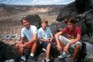
 Herb and Boys on Petroglyph HikeAt the Visitor Center, we learned that the park contained more than 25,000 Native American and Hispanic petroglyphs, making it one of the largest petroglyph concentrations in all of North America. The ranger told us that the best way to see them up close was to hike one of the 3 paved trails in the Boca Negra Canyon section of the park just down the road from the Visitor Center.
We chose to hike the Mesa Point Trail, which started at the base of the mesa and climbed through a series of switchbacks to the summit. Along the way we saw enough petroglyphs for a lifetime. Most of the ones we saw were carved between 1300 and 1600 by the ancestors of today's Pueblo Indians. By chipping away at the desert varnish on the surface of these volcanic rocks, they created beautiful images in the lighter colored rock underneath. We saw images of birds, serpents, reptiles, spirals, and our unanimous favorite--Kokopelli, the hump-backed flute player. From the top of the mesa, there were tremendous views of the nearby Sandia Mountains and the outskirts of the city of Albuquerque. The whole hike took us about a half hour.
Description
Petroglyph National Monument, located right outside Albuquerque, contains one of the largest petroglyph concentrations in North America. Along the 17-mile West Mesa, there are more than 25,000 Native American and Hispanic petroglyphs etched into the dark boulders along the volcanic cliffs.
Long ago, people discovered that when they used a stone chisel and hammerstone to chip away at the thin desert varnish on these rocks, they exposed a lighter-color rock underneath. This provided the perfect surface for their rock art--or petroglyphs. The earliest rock images were made by nomadic people 2,000 to 3,000 years ago. However, the majority of the petroglyphs found here were carved from about 1300 through the late 1600s by the ancestors of today's Pueblo Indians and are referred to as the Rio Grande style of rock art. Images in the Rio Grande style include birds, serpents, reptiles, insects, spirals, and geometric designs. The best known image is that of Kokopelli, the hump-backed flute player.
The best place to observe these petroglyphs up close is the Boca Negra Canyon section of the park. From here, there are three paved trails of varying difficulty (from 5 to 30 minutes round trip) that provide plenty of opportunities for viewing petroglyphs--Cliff Base, Macaw, and Mesa Point. The Mesa Point Trail starts at the base of the mesa and climbs through a series of switchbacks to the summit of the mesa. Along the way there are numerous petroglyphs that you can observe up close as well as outstanding views of the Sandia Mountains.
Videos
-
Petroglyph National Monument
- ‹ previous
- 11 of 36
- next ›
Petroglyph National Monument location map in "high definition"
Javascript is required to view this map.
