- Home
- About
- Map
- Trips
- Bringing Boat West
- Migration West
- Solo Motorcycle Ride
- Final Family XC Trip
- Colorado Rockies
- Graduates' XC Trip
- Yosemite & Nevada
- Colorado & Utah
- Best of Utah
- Southern Loop
- Pacific Northwest
- Northern Loop
- Los Angeles to NYC
- East Coast Trips
- Martha's Vineyard
- 1 Week in Quebec
- Southeast Coast
- NH Backpacking
- Martha's Vineyard
- Canadian Maritimes
- Ocracoke Island
- Edisto Island
- First Landing '02
- Hunting Island '02
- Stowe in Winter
- Hunting Island '01
- Lake Placid
- Chesapeake
- Provincetown
- Hunting Island '00
- Acadia in Winter
- Boston Suburbs
- Niagara Falls
- First Landing '99
- Cape Hatteras
- West Coast Trips
- Burning Man
- Utah Off-Roading
- Maui
- Mojave 4WD Course
- Colorado River Rafting
- Bishop & Death Valley
- Kauai
- Yosemite Fall
- Utah Off-Road
- Lost Coast
- Yosemite Valley
- Arizona and New Mexico
- Pescadero & Capitola
- Bishop & Death Valley
- San Diego, Anza Borrego, Joshua Tree
- Carmel
- Death Valley in Fall
- Yosemite in the Fall
- Pacific Northwest
- Utah Off-Roading
- Southern CA Deserts
- Yosemite & Covid
- Lake Powell Covid
- Eastern Sierra & Covid
- Bishop & Death Valley
- Central & SE Oregon
- Mojave Road
- Eastern Sierra
- Trinity Alps
- Tuolumne Meadows
- Lake Powell Boating
- Eastern Sierra
- Yosemite Winter
- Hawaii
- 4WD Eastern Sierra
- 4WD Death Valley +
- Southern CA Deserts
- Christmas in Tahoe
- Yosemite & Pinnacles
- Totality
- Yosemite & Sierra
- Yosemite Christmas
- Yosemite, San Diego
- Yosemite & North CA
- Seattle to Sierra
- Southwest Deserts
- Yosemite & Sierra
- Pacific Northwest
- Yosemite & South CA
- Pacific Northwest
- Northern California
- Southern Alaska
- Vancouver Island
- International Trips
- Index
- Tips
- Books
- Photos/Videos
- Search
- Contact
El Malpais National Monument, NM
Sunday, August 11, 2002 - 3:00am by Lolo
80 miles and 1.5 hours from our last stop
Travelogue
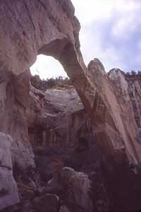
 Lolo's solo photo of La Ventana Natural ArchThere was so much to see and do along I40 that if we stopped at all the sights, we'd never get home. We decided to skip El Morro National Monument this time and stop at El Malpais National Monument instead. There were two separate approaches to visiting El Malpais. Highway 53 led to the privately-owned Bandera Crater and Ice Caves. Although that sounded interesting, we decided to stick with the federally-owned portion along Highway 117. We tend to shy away from commercial establishments in natural areas--usually they're a rip-off.
Our first stop along 117 was the Sandstone Bluffs Overlook where we had sweeping views of the cinder cones and lava flows that make up El Malpais. I guess it was the barrenness of this landscape that caused the Spanish to name this land El Malpais, which means "badlands."
We continued on to the parking lot for La Ventana Natural Arch, the second largest natural arch in New Mexico. After a picnic lunch, I suggested to the family that we take the short ½-mile hike to the base of the arch where we would get a much better perspective of it. They weren't buying it. After this morning's fiasco in Red Rock State Park where one of my short hikes turned into a multi-hour adventure (we got lost), no one was interested in another one of my short hikes. So, I took the cameras and went alone. I stood with satisfaction under the broad expanse of the arch and took the classic photograph of the sky through the arch. Maybe I'll show it to them and maybe I won't.
Description
El Malpais National Monument, located in the lava beds of western New Mexico, is considered one of the best examples of volcanic landscapes in the U.S. El Malpais, which means "the badlands" in Spanish, encompasses over 100,000 acres of sandstone cliffs and arches, cinder cones, lava flows, a 17-mile-long lava-tube system, Anasazi ruins, and even some ice caves.
There are two approaches to visiting El Malpais. The first approach is to take Highway 53, just west of Grants, to the privately owned Bandera Crater and Ice Caves. The National Park Service is currently trying to acquire this land, but until do, there is an admission fee to hike up to the crater or walk to the edge of the ice caves. The second approach to visiting El Malpais is to take Highway 117, about 7 miles east of Grants. Along this road is the Sandstone Bluffs Overlook from which there are panoramic views of the volcanic landscape and the La Ventana Natural Arch, the second largest natural arch in New Mexico. An easy ½ mile trail leads to the base of this 165-foot arch.
The 7.5-mile-long (one way), fairly difficult Zuni-Acoma Trail connects Highways 53 and 117. This ancient Puebloan trade route traverses El Malpais and crosses four major lava flows.
- ‹ previous
- 27 of 36
- next ›
El Malpais National Monument location map in "high definition"
Javascript is required to view this map.
