- Home
- About
- Map
- Trips
- Bringing Boat West
- Migration West
- Solo Motorcycle Ride
- Final Family XC Trip
- Colorado Rockies
- Graduates' XC Trip
- Yosemite & Nevada
- Colorado & Utah
- Best of Utah
- Southern Loop
- Pacific Northwest
- Northern Loop
- Los Angeles to NYC
- East Coast Trips
- Martha's Vineyard
- 1 Week in Quebec
- Southeast Coast
- NH Backpacking
- Martha's Vineyard
- Canadian Maritimes
- Ocracoke Island
- Edisto Island
- First Landing '02
- Hunting Island '02
- Stowe in Winter
- Hunting Island '01
- Lake Placid
- Chesapeake
- Provincetown
- Hunting Island '00
- Acadia in Winter
- Boston Suburbs
- Niagara Falls
- First Landing '99
- Cape Hatteras
- West Coast Trips
- Burning Man
- Utah Off-Roading
- Maui
- Mojave 4WD Course
- Colorado River Rafting
- Bishop & Death Valley
- Kauai
- Yosemite Fall
- Utah Off-Road
- Lost Coast
- Yosemite Valley
- Arizona and New Mexico
- Pescadero & Capitola
- Bishop & Death Valley
- San Diego, Anza Borrego, Joshua Tree
- Carmel
- Death Valley in Fall
- Yosemite in the Fall
- Pacific Northwest
- Utah Off-Roading
- Southern CA Deserts
- Yosemite & Covid
- Lake Powell Covid
- Eastern Sierra & Covid
- Bishop & Death Valley
- Central & SE Oregon
- Mojave Road
- Eastern Sierra
- Trinity Alps
- Tuolumne Meadows
- Lake Powell Boating
- Eastern Sierra
- Yosemite Winter
- Hawaii
- 4WD Eastern Sierra
- 4WD Death Valley +
- Southern CA Deserts
- Christmas in Tahoe
- Yosemite & Pinnacles
- Totality
- Yosemite & Sierra
- Yosemite Christmas
- Yosemite, San Diego
- Yosemite & North CA
- Seattle to Sierra
- Southwest Deserts
- Yosemite & Sierra
- Pacific Northwest
- Yosemite & South CA
- Pacific Northwest
- Northern California
- Southern Alaska
- Vancouver Island
- International Trips
- Index
- Tips
- Books
- Photos/Videos
- Search
- Contact
Tadoussac, QB
Wednesday, August 18, 2010 - 1:00pm by Lolo
45 miles and 0.75 hours from our last stop - 1 night stay
Travelogue
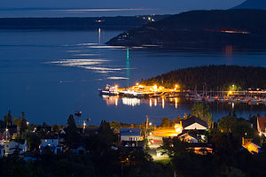 Night View of Tadoussac Village from Campground - TJGThe scenic Route du Fleuve ended in La Malbaie, so we were back on Route 138, the main highway through the Charlevoix region. Although not listed as scenic, this road was extremely hilly and scenic as well. Eventually the road dead ended at the confluence of the St. Lawrence and Saguenay Rivers in the tiny village of Baie-Ste-Catherine. Fortunately, there was a free, 10-minute ferry across to the village of Tadoussac and the continuation of Route 138. Once we got on the ferry we would be leaving the Charlevoix region of Quebec and entering the Manicouagan.
According to the guide books, whales are frequently sighted during the ferry crossing. These waters are very rich in marine life. As many as 1,500 whales, representing 10 to 12 species (minkes, humpbacks, blue, beluga, etc.), come to Saguenay Bay to summer vacation from mid-June through late October. So, we looked and we looked, but no whales today.
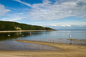 Tadoussac Beach - TJGNot knowing where we were going or what we wanted to do as of yet, I asked Herb to drive the RV through the town. For a town with a population of only 913 people, it was really hopping. All 913 residents must have invited a friend or two and were out roaming the streets. We couldn’t find parking anywhere. After navigating Herb down a difficult to turn around in dead end, he politely suggested that we find a campground, park the RV, and come back to town on foot or bike.
I knew of only one campground, called Camping Tadoussac, and it was located high atop the hill overlooking the town. I would later find out that there was another campground slightly east of town near the region known as Dunes de Sable. We maneuvered the RV out of town, and got back on Route 138 up a steep hill to the campground. Once again, no one spoke English in the office, but I did manage to figure out that there were some premier sites with views and was able to claim the last one. It was great. Just a 50-foot walk from our campsite were benches where we could sit and look down over the red-roofed houses of Tadoussac and out across the water. Now we were talking.
 Mom wading the St. Lawrence - TJGI think Herb would have been content to just stay there and enjoy the views, and probably a well-earned beer or too, but I had other plans in mind—like lunch at a restaurant I had read about in my Frommer’s guide. So, the family marched back down the hill into town and looked for Café Boheme (239 rue des Pionniers), a little restaurant started by two backpackers a few years back, who came to Tadoussac, loved it, and never left. There was a pretty long wait, but the boys and Herb didn’t mind at all as they sat in a room upstairs with WIFI, heads bent and fingers flying over their Droids as they made contact with civilization once again. Since I am the only family member with a cell phone that only makes phone calls, I took a walk up and down the block to explore. Right at the predicted ½ hour wait, we were called to our table. The food was great and quite healthy. We all had different varieties of paninis and salads, and some specialty coffees for dessert. It was delicious.
After lunch, we walked around town where I tried to find Tadoussac hat pins to add to the boys’ collection. None of the shopkeepers understood what I was asking for, but eventually after much miming, I was pointed in the right direction. I selected two shaped like “baleines” (that’s whale for those non-French speakers) and happily brought them out to the boys. I’m not sure how interested they really are anymore in continuing their very impressive hat pin collection from the places we have visited, but I still was. I kind of think they are too.
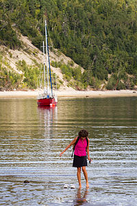
 Dad with Camera - AJGWe strolled down towards the beach past the Hotel Tadoussac, built in 1864 to save the town’s economy by bringing wealthy tourists to the region. It had the traditional bright red roof seen so often in the Charlevoix region, and certainly did look very inviting to stay in. Just beyond the hotel was a boardwalk with steps down to a beach on a small bay where the Saguenay River flows out into the St. Lawrence. I took my shoes off and got my toes wet a bit – just to say that I went in the St. Lawrence. We walked along the beach a short distance, but didn’t go all the way to Rouge Point because the boys wanted to get back to go for a long run. They said they could see it just fine from where we were.
The walk back up to the campground was steep. I can’t believe how hilly the northern shore of the St. Lawrence is. It does, however, provide for some great viewpoints. While the boys ran, Herb and I claimed one of the benches on the edge of the bluff in the campground. As I jokingly said, let’s look for the boys running below, sure enough I caught sight of two tiny runners crossing a street before disappearing again behind the red-roofed buildings. They looked so cute.
That night we just hung around the campground with three tripods setup along the bluff. The view really was one of the nicest we have ever had from a campsite.
The next morning while on the ferry leaving Tadoussac, Herb and I saw what we at first thought were white caps in the distance, but after watching how these little white caps behaved, we realized that we had finally spotted some baleine—or at least the tips of some baleine tails. Nothing quite as dramatic as whales breaching alongside the ferry, but we would take what we could get.
Description
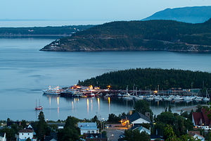 View of Tadoussac Village from Campground - TJGAbout 45 miles north of La Malbaie, Route 138 dead ends at the Saguenay River in the village of Baie-Ste-Catherine. A free, 10-minute car ferry connects Baie-Ste-Catherine with the village of Tadoussac (pop. 913), the southernmost point of the Manicouagan Region. The views on the short ferry ride are quite dramatic, and whale sightings are not uncommon.
Tadoussac was established in the 1600s and is the oldest permanent European settlement north of Florida. Missionaries settled here, and it was also a stop along the fur-trading route. The village would have gone out of existence in the mid 19th century, if it hadn’t been for the building of the Hotel Tadoussac in 1864, which drew wealthy tourists from Montreal.
Besides this very impressive hotel, there is not much else in the town. There is a whaling educational center on the river with exhibits and videos about the whales that frequent this area from mid-June to late October. There are several cruise companies offering a variety of whale-watching tours to see minke, humpback, and even blue whales. Along the main street through town there are several restaurants and shops. One of the more interesting restaurants is Café Boheme, started by two backpackers that came to Tadoussac and never left. It’s a great stop for healthy fare: stuffed waffles, soups, quiche, salads, and paninis. Down by the waters edge, there is a lovely boardwalk and beach. You can walk along the beach on the Sentier de la plage trail (2 km round trip) to Rouge Point.
There are two campgrounds in Tadoussac:
• Camping Tadoussac (428 rue Bateau-Passeur) – high atop a hill overlooking the town; 200 grassy camp sites, some with spectacular views of the river and town below; walking distance to town
• Chalets-Camping Domalne des Dunes (585 Chemin du Moulin à Baude) – 10 RV and 30 tenting sites
For more information on Tadoussac, the following website is quite helpful: http://www.tadoussac.com/2010/home.php
- ‹ previous
- 5 of 11
- next ›
Tadoussac location map
Javascript is required to view this map.
