- Home
- About
- Map
- Trips
- Bringing Boat West
- Migration West
- Solo Motorcycle Ride
- Final Family XC Trip
- Colorado Rockies
- Graduates' XC Trip
- Yosemite & Nevada
- Colorado & Utah
- Best of Utah
- Southern Loop
- Pacific Northwest
- Northern Loop
- Los Angeles to NYC
- East Coast Trips
- Martha's Vineyard
- 1 Week in Quebec
- Southeast Coast
- NH Backpacking
- Martha's Vineyard
- Canadian Maritimes
- Ocracoke Island
- Edisto Island
- First Landing '02
- Hunting Island '02
- Stowe in Winter
- Hunting Island '01
- Lake Placid
- Chesapeake
- Provincetown
- Hunting Island '00
- Acadia in Winter
- Boston Suburbs
- Niagara Falls
- First Landing '99
- Cape Hatteras
- West Coast Trips
- Burning Man
- Utah Off-Roading
- Maui
- Mojave 4WD Course
- Colorado River Rafting
- Bishop & Death Valley
- Kauai
- Yosemite Fall
- Utah Off-Road
- Lost Coast
- Yosemite Valley
- Arizona and New Mexico
- Pescadero & Capitola
- Bishop & Death Valley
- San Diego, Anza Borrego, Joshua Tree
- Carmel
- Death Valley in Fall
- Yosemite in the Fall
- Pacific Northwest
- Utah Off-Roading
- Southern CA Deserts
- Yosemite & Covid
- Lake Powell Covid
- Eastern Sierra & Covid
- Bishop & Death Valley
- Central & SE Oregon
- Mojave Road
- Eastern Sierra
- Trinity Alps
- Tuolumne Meadows
- Lake Powell Boating
- Eastern Sierra
- Yosemite Winter
- Hawaii
- 4WD Eastern Sierra
- 4WD Death Valley +
- Southern CA Deserts
- Christmas in Tahoe
- Yosemite & Pinnacles
- Totality
- Yosemite & Sierra
- Yosemite Christmas
- Yosemite, San Diego
- Yosemite & North CA
- Seattle to Sierra
- Southwest Deserts
- Yosemite & Sierra
- Pacific Northwest
- Yosemite & South CA
- Pacific Northwest
- Northern California
- Southern Alaska
- Vancouver Island
- International Trips
- Index
- Tips
- Books
- Photos/Videos
- Search
- Contact
San Diego, CA
Sunday, February 17, 2019 - 10:30am by Lolo
550 miles and 10 hours from our last stop - 2 night stay
Travelogue
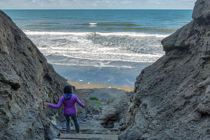 Trail down to Black's BeachAfter a very cool and rainy winter in Sonoma Valley, Herb was craving some well-need sun and warmth. In fact, that was the major impetus behind the decision to make the long drive to Baja.
The weather this winter had been so crazy throughout the West that we shouldn’t have been totally surprised when on our way over Tejon Pass, just north of LA, it started to snow. Fortunately, we were able to get over the pass before that section of I5 was closed.
Exhausted from our long drive, we stopped at a Days Inn in Encinitas for the night.
San Diego is a very worthy destination in itself, so rather than rushing across the border the next day, we decided to enjoy a day in San Diego visiting some old favorites and exploring some new.
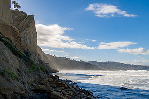 Winter erosion on Black's BeachWe drove along the coast from Encinitas, stopping at Black’s Beach on the southern end of Torrey Pines State Beach, near the Glider Port. This was an old favorite from past visits. Getting to the beach requires descending 320 feet down a steep trail, with steps and handrails in the steep sections to make things a bit easier.
Upon reaching the bottom, we were astounded to find that there was barely any beach left. What had happened to our beautiful, wide sandy beach?
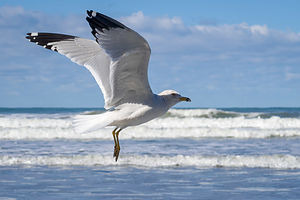
We had an informative exchange with a naked man feeding the seagulls. I tried to remain in eye contact at all times. Firstly, he explained that this is what winter storms do to this beach every year, with this one being a particularly bad one, but it would return in the spring. Secondly, upon hearing about our plans for the following week, he quite alarmedly warned us of the dangers and safety issues of traveling through northern Baja. “Be really careful,” was his parting words.
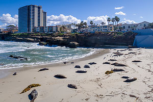 The sea lions of La JollaMy worst fears were coming to life - murderers, rapists, drug cartels, caravans filled with terrorists, “oh my.” Maybe Trump and Fox News were right. Nah, just kidding.
Thankfully, cooler heads (Herb’s) prevailed, so rather than turn back and rush towards the safety of home (my idea), we forged on. Not to give away the ending, but the Mexican people turned out to be some of the friendliest, most generous people we have met in our travels. Turns out they are just like us. As the great Mark Twain once said:
“Travel is fatal to prejudice, bigotry, and narrow-mindedness, and many of our people need it sorely on these accounts. Broad, wholesome, charitable views of men and things cannot be acquired by vegetating in one little corner of the earth all one's lifetime.”
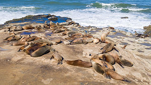
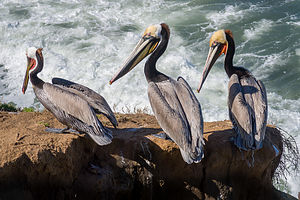 California brown pelicansBased on our friend’s suggestion, we headed next to La Jolla Cove to see the seals and sea lions. We had been to La Jolla before, but somehow had missed the stretch of waterfront where the seals and sea lions like to hang out. There were dozens of them, just chillin’ on the beach. Unlike Point Reyes where you had to stay back at least a 100 yards from the sea lions, here you could practically ride them - if it wasn’t for the disembodied voice over a loudspeaker which piped up whenever a person got a bit too close.
As interesting as the sea lions, were the California brown pelicans also inhabited this stretch of the waterfront. I had never seen so many so close before. Their beaks were certainly quite impressive and very capable of storing a good meal.
After some delicious Italian sandwiches at Sicilia Bella, we headed over to Cabrillo National Monument out at the tip of the Point Luma Peninsula. We had been there a few years back, but it had rained so hard that we felt it was worth a return visit.
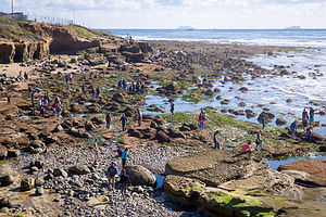 Point Loma tide poolsUnfortunately, we were thwarted once again - this time with Presidents Day traffic. The road leading up to the gatehouse was backed up for almost a mile. Instead of waiting, we decided to park alongside the road next to the Naval Cemetery and walk down the road to the tidepools.
The walk turned out to be longer and steeper than we expected, but eventually we got there and joined dozens of others scrambling along the rocks down to the tide pools. At the national park booth, I picked up a brochure identifying the various sea life to be found in the pools, but for some reason, nobody was home. We did not see a single crustacean, anemone, or fish of any sort. Still it was very pretty.
Our final stop of the day was the Costco in Chule Vista, where we stocked up on some supplies and exchanged dollars for pesos.
Tomorrow was the big day!
Description
The following is in no way intended to be a complete listing of sights to see in the San Diego area, but just those that we chose to visit during our quick pass through.
Torrey Pine State Beach
 Resident of Black's BeachTorrey Pines State Beach in La Jolla extends for three miles from Carmel Valley Road in the north to the Glider Port at Torrey Pines Scenic Drive.
The north section of the beach is more easily accessible by car and is the choice for families.
Black’s Beach on the southern end is only accessible via two steep trails from the top of the cliff, where the parking lots are. This difficult-to-get-to beach is mostly frequented by two types: surfers looking to enjoy the huge winter swells, and nudists looking to enjoy some privacy. The nudists tend to hang out north of the Glider Port, while the surfers head to the south.
The south trail, which begins just south of the Glider Port, is easier and better maintained than the north trail, in that it has steps and handrails in the steeper segments. The north trail is much steeper and should be avoided if you are subject to vertigo. Both trails are about 1,000 feet long and have an elevation loss of about 320 feet.
It’s also fun to watch the hang gliders and paragliders soar from the Glider Port, atop the cliffs above Black Beach.
La Jolla
 The good life for a Lo Jolla sea lionThe Native Americans originally called the site La Hoya, meaning “the cave,” referring to the grottoes that dot the shoreline. When the Spaniards arrived, they changed the name to La Jolla (same pronunciation), meaning “the jewel.”
Today, La Jolla certainly is a jewel, and a very expensive one at that. With its stunning coastline and upscale restaurants, shops, and galleries along Girard and Prospect Streets, it is one of the most affluent communities in America.
Along the waterfront is La Jolla Cove, a small cove flanked by two rocky points, where seals and sea lions, as well as California brown pelicans, like to hang out. The ocean here is part of the protected La Jolla Ecological Reserve and Marine Park.
The Museum of Contemporary Art San Diego is located on a bluff above the waterfront in what was once the residence of philanthropist Ellen Browning Scripps. The museum has over 4,000 works representing every major art movement of the past half century, with a particularly strong emphasis on California artists.
The University of California, San Diego is located in La Jolla, as well as the Scripps Institution of Oceanography, Scripps Research Institute, and Salk Institute.
Cabrillo National Monument
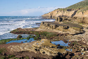 Point Loma tide poolsLocated at the tip of the Point Luma Peninsula in San Diego, the Cabrillo National Monument marks the site where in 1542 Juan Rodriguez Cabrillo became the first European to set foot on the West Coast of the United States. The Visitor Center has an “Age of Exploration” exhibit and film.
Right past the gatehouse, a road leads down to the tide pools, where you can clamber around on the rocks looking for tiny crustaceans, fish, and other sea life that live in these pools.
After visiting the tide pools, drive back up the road to the main road and turn right.Near the Visitor Center is a small circular plaza with a 14-foot statue of the explorer. The Plaza has an excellent view of San Diego and the harbor.
A short walk from there leads to the Old Point Loma Lighthouse, the highest point in the park. The lighthouse and adjacent Assistant Keepers’ Quarters has exhibits presenting what life was like for the lighthouse keepers in the 1880s.
Just south of the lighthouse is the Whale Overlook, a prime vantage point for viewing migrating Pacific gray whales traveling back and forth between Alaska and Baja California during the months of December through March.
The self-guided, two-mile Bayside Trail begins near the lighthouse and leads visitors through one of the last remaining remnants of a coastal sage scrub forest in the world. This trail offers views of San Diego harbor and the city beyond.
- 1 of 14
- next ›
San Diego location map in "high definition"
Javascript is required to view this map.
