- Home
- About
- Map
- Trips
- Bringing Boat West
- Migration West
- Solo Motorcycle Ride
- Final Family XC Trip
- Colorado Rockies
- Graduates' XC Trip
- Yosemite & Nevada
- Colorado & Utah
- Best of Utah
- Southern Loop
- Pacific Northwest
- Northern Loop
- Los Angeles to NYC
- East Coast Trips
- Martha's Vineyard
- 1 Week in Quebec
- Southeast Coast
- NH Backpacking
- Martha's Vineyard
- Canadian Maritimes
- Ocracoke Island
- Edisto Island
- First Landing '02
- Hunting Island '02
- Stowe in Winter
- Hunting Island '01
- Lake Placid
- Chesapeake
- Provincetown
- Hunting Island '00
- Acadia in Winter
- Boston Suburbs
- Niagara Falls
- First Landing '99
- Cape Hatteras
- West Coast Trips
- Burning Man
- Utah Off-Roading
- Maui
- Mojave 4WD Course
- Colorado River Rafting
- Bishop & Death Valley
- Kauai
- Yosemite Fall
- Utah Off-Road
- Lost Coast
- Yosemite Valley
- Arizona and New Mexico
- Pescadero & Capitola
- Bishop & Death Valley
- San Diego, Anza Borrego, Joshua Tree
- Carmel
- Death Valley in Fall
- Yosemite in the Fall
- Pacific Northwest
- Utah Off-Roading
- Southern CA Deserts
- Yosemite & Covid
- Lake Powell Covid
- Eastern Sierra & Covid
- Bishop & Death Valley
- Central & SE Oregon
- Mojave Road
- Eastern Sierra
- Trinity Alps
- Tuolumne Meadows
- Lake Powell Boating
- Eastern Sierra
- Yosemite Winter
- Hawaii
- 4WD Eastern Sierra
- 4WD Death Valley +
- Southern CA Deserts
- Christmas in Tahoe
- Yosemite & Pinnacles
- Totality
- Yosemite & Sierra
- Yosemite Christmas
- Yosemite, San Diego
- Yosemite & North CA
- Seattle to Sierra
- Southwest Deserts
- Yosemite & Sierra
- Pacific Northwest
- Yosemite & South CA
- Pacific Northwest
- Northern California
- Southern Alaska
- Vancouver Island
- International Trips
- Index
- Tips
- Books
- Photos/Videos
- Search
- Contact
Portage Glacier, AK
Tuesday, July 18, 2006 - 2:00pm by Lolo
40 miles and 1 hour from our last stop - 2 night stay
Travelogue
It had been a very long driving day. It was hard to believe that just that morning we had posed for our family shot in front of the elusive Mt. McKinley.
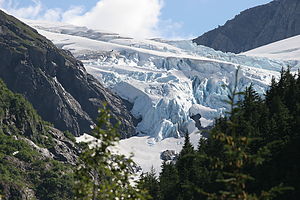
 Middle Glacier view from campsiteWe were rather nonchalant about finding camping for the night, hence our concern when we found that our intended destination for the night - Bird Creek State Recreation Site - was completely full. The next closest camping was at Portage Glacier, another 30 miles away. We were pretty done and ready to settle in for the night, but we didn't have much choice but to drive on.
Portage Glacier was a stop we wanted to make anyway. Almost everyone we had asked had said that Portage Glacier was a must see. We were extremely pleased when we pulled into the Williwaw Creek Campground in the Chugach National Forest, just 4 miles down the Portage Glacier Road. The sites were extremely large and private and, best of all, we were able to back out motorhome into a site with a fabulous view of Middle Glacier.
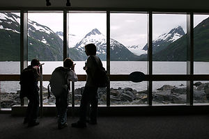
The next morning we awoke to brilliant sunshine, something we had not seen since our arrival in Alaska. What a difference. Rather than move the RV, we decided to hike the Nature Trail from the campground over to the Begich, Boggs Visitor Center. Alaska must get some great funding from the federal government because this had to be the most state-of-the-art visitor center we've ever seen--and we've seen plenty. Besides the wonderful displays on glaciers, there was a fabulous award-winning film entitled Voices from the Ice. It was one of the best visitor center videos we have ever seen. Even the boys didn't sleep through it. There is also a spectacular view of Portage Lake from the visitor center's large picture windows, but unfortunately Portage Glacier has receded so far that it can no longer be seen from here. The only way to see it is by tour boat, but there was no way I was going to get Herb on another crowded organized tour.
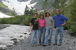
 Family on Byron Glacier TrailInstead, we opted to hike on our own to Byron Glacier, which turned out to be a great choice. The trailhead was about a mile further down the road towards the tour boat dock. The trail itself was quite lovely--a ¾-mile hike along the cascading Byron Creek to the base of Byron Glacier. We even played on the snowfield--much more fun than just looking at a glacier from a tour boat. The hike was great, but I kind of wished our motorhome was parked at the trailhead rather than 4 miles away back at the campground. Oh well, at least it was a beautiful day.
Back at the campground, we actually got into shorts and sunbathed. It felt great to finally get some sunshine. Little did we know that it was to be the last we would see of it for some time. We just hung out and relaxed the rest of that afternoon and anxiously awaited the arrival of our friends from home, the Kalchbrenners, who were flying out from New Jersey to meet up with us for the rest of our trip. They had traveled with us for parts of our first 3 cross country trips, but had been unable to join us for the last 4, so we were greatly looking forward to them traveling with us again.
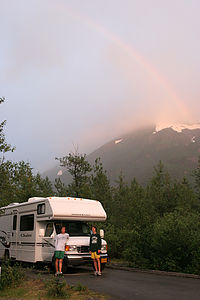
 Rainbow over Winnie with boysWhile waiting, I decided to call the Homer Spit Campground, just to make sure we would have no trouble getting 2 beach-front sites for tomorrow and the next couple of nights. I had called a few weeks ago from home and had been assured that it shouldn't be a problem and that reservations weren't necessary. We really like to avoid making reservations whenever possible because we don't like being tied down to a strict itinerary. The downside, however, is that sometimes you miss out on something you really want to do. Sure enough, the guy on the phone told me that there were no more beach sites available for the next few nights. I panicked and called a commercial campground that was not on the Spit but claimed to have water views, and I made a reservation for 2 nights, 2 nights from now, leaving the next night open to chance. I wasn't real sure if this was the right thing to do, because I had a feeling that the Spit was the place to be when staying in Homer. Well, I guess we would see tomorrow.
The Kalchbrenners pulled in around 9:00 that night, exhausted from a very long travel day. However, as always, they were in great spirits and raring to go. Also, since it never seems to get dark in Alaska, 9:00 didn't feel so late at all. At least they got to see our great view of Middle Glacier before collapsing into bed.
The next morning our plan was to head towards Homer and check out the sights along the way.
Description
Portage Glacier is located about an hour south of Anchorage, via the Portage Glacier Road at Milepost 78.9 of the Seward Highway. A 5 ½ mile access road takes you through the Portage Valley to the National Forest Service's Begich, Boggs Visitor Center at Portage Lake.
 Begich, Boggs Visitor Center viewThe visitor center is very impressive and state-of-the art--obviously very well funded. Besides the wonderful displays on glaciers, there is a large picture window overlooking the narrow outlet of Portage Lake and an award-winning film entitled Voices from the Ice. Unfortunately, Portage Glacier is no longer visible from the visitor center because it has receded so much over the last few decades. The only way to see Portage Glacier is to take a one-hour cruise on the 200-passenger Ptarmigan, which takes you up close to the face of the glacier.
From the visitor center, you can take a stroll along the shores of Portage Lake and see some small icebergs in the lake. Another alternative is to hike the ¾-mile Byron Glacier Trail along Byron Creek and up to the glacier itself. With caution, you can actually play around on the snowfield at the foot of the glacier. The trailhead for this hike is at a parking lot about halfway between the Visitors Center and the boat dock.
There are two National Forest campgrounds along the Portage Glacier Road. The Black Bear Campground at mile 3.7 is small and can only accommodate 2 medium-sized trailers. However, the larger 60-site Williwaw campground at mile 4.1 can accommodate motorhomes of all sizes. It has spacious sites, many of which have views of Middle Glacier. There is even an observation deck along the Williwaw Creek where you can see spawning salmon during the summer if you are lucky enough to be there when they are running.
- ‹ previous
- 5 of 12
- next ›
Portage Glacier location map
Javascript is required to view this map.
