- Home
- About
- Map
- Trips
- Bringing Boat West
- Migration West
- Solo Motorcycle Ride
- Final Family XC Trip
- Colorado Rockies
- Graduates' XC Trip
- Yosemite & Nevada
- Colorado & Utah
- Best of Utah
- Southern Loop
- Pacific Northwest
- Northern Loop
- Los Angeles to NYC
- East Coast Trips
- Martha's Vineyard
- 1 Week in Quebec
- Southeast Coast
- NH Backpacking
- Martha's Vineyard
- Canadian Maritimes
- Ocracoke Island
- Edisto Island
- First Landing '02
- Hunting Island '02
- Stowe in Winter
- Hunting Island '01
- Lake Placid
- Chesapeake
- Provincetown
- Hunting Island '00
- Acadia in Winter
- Boston Suburbs
- Niagara Falls
- First Landing '99
- Cape Hatteras
- West Coast Trips
- Burning Man
- Utah Off-Roading
- Maui
- Mojave 4WD Course
- Colorado River Rafting
- Bishop & Death Valley
- Kauai
- Yosemite Fall
- Utah Off-Road
- Lost Coast
- Yosemite Valley
- Arizona and New Mexico
- Pescadero & Capitola
- Bishop & Death Valley
- San Diego, Anza Borrego, Joshua Tree
- Carmel
- Death Valley in Fall
- Yosemite in the Fall
- Pacific Northwest
- Utah Off-Roading
- Southern CA Deserts
- Yosemite & Covid
- Lake Powell Covid
- Eastern Sierra & Covid
- Bishop & Death Valley
- Central & SE Oregon
- Mojave Road
- Eastern Sierra
- Trinity Alps
- Tuolumne Meadows
- Lake Powell Boating
- Eastern Sierra
- Yosemite Winter
- Hawaii
- 4WD Eastern Sierra
- 4WD Death Valley +
- Southern CA Deserts
- Christmas in Tahoe
- Yosemite & Pinnacles
- Totality
- Yosemite & Sierra
- Yosemite Christmas
- Yosemite, San Diego
- Yosemite & North CA
- Seattle to Sierra
- Southwest Deserts
- Yosemite & Sierra
- Pacific Northwest
- Yosemite & South CA
- Pacific Northwest
- Northern California
- Southern Alaska
- Vancouver Island
- International Trips
- Index
- Tips
- Books
- Photos/Videos
- Search
- Contact
Mojave National Preserve, CA
Friday, November 7, 2014 - 8:00am by Lolo
146 miles and 3 hours from our last stop
Travelogue
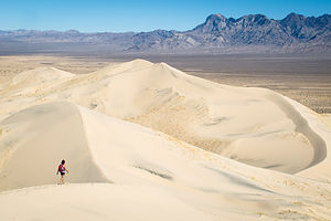 Kelso Dune with Tiny LoloThe Mojave National Preserve makes for an easy side trip when traveling along I15 between Los Angeles and Las Vegas, whether you have just an extra hour or a full day. As I mentioned in the previous stop, the Preserve doesn’t really have any accessible camping options for motorhomes when entering from the north, so we were just going to make this a half-day detour on our way to Vegas.
As recommended by the National Park website, we took the Kelbaker Road exit off of I15 and drove south 34 miles through a barren landscape of cinder cones and lava flows to the Kelso Depot Visitor Center. It was extremely desolate and we passed only about three cars during the entire stretch. Signs kept warning us to “Watch for Tortoise,” but try as I might, no desert tortoises were to be seen. Far too often, these iconic and endangered residents of the Mojave are able to survive some of the most extreme conditions in the world, only to meet their fate under a tourist’s tire. We were extra careful not to do that, but it would have been really cool to see one alongside the road.
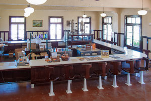 Kelso Depot Visitor CenterThe Kelso Depot Visitor Center was one of the prettiest National Park visitor centers I have seen. This beautiful Mission Revival style building was built in the 1920s to serve as a railroad depot, providing food, recreation, and accommodates for Union Pacific Railroad employees. It was called the “Kelso Depot and Clubhouse,” and it had a conductor’s room, telegraph office, dormitory room for staff, boarding rooms for railroad crewmen, a billiard room, library room, ticket office, and lunch counter.
I would have loved to have had lunch there – and spun around on one of those old stools -- but unfortunately it hasn’t served lunch in many a decade. With progress in diesel technology, fewer and fewer crew members were needed to operate and maintain the line, so the Union Pacific closed the depot in 1985.Fortunately, due to the efforts of local residents and others across the region, the building was saved from demolition and put under the control of the Bureau of Land Management.
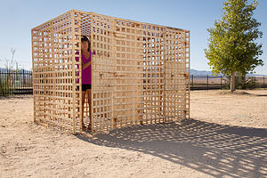 Lolo in Kelso Depot JailWith the passage of the California Desert Protection Act of 1994, the Mojave National Preserve was created, and the Kelso Depot, as well as 1.6 million acres of sand dunes, Joshua tree forests, wildflowers, and volcanic cinder cones, came under the protection of the National Park Service. Renovation was begun on the depot in 2002, and it reopened to the public in 2005 as the Mojave National Preserve Visitor Center.
There are still about a dozen small houses on the other side of the track, where the much smaller crews needed to maintain the line live.
We had time for only one hike, so after a brief debate over the merits of the Kelso Dunes vs. Teutonia Peak, we decided to go with the dunes. I think either choice would have been great.
The Kelso Dunes are located just a short distance from the Visitor Center down the unpaved Kelso Dunes Road. The road was well-graded, so it was perfectly fine for RVs.
 Herb on Kelso Dune SummitThe distances for dune hikes are always deceptive. Three miles might not sound like much, but when you are slogging through soft sand, it can be fairly strenuous. And, did I mention that this is the second highest dune in California?
As those that have hiked on a dune before know, the shifting sands prevent anything resembling a trail from forming, so it is free form – just get to the top any which way you can.
This was one big dune, cover 45 square miles, and rising 650 feet above the desert floor. It made me feel very small and insignificant – just the way Herb likes me – and he captured that in several of his photographs.
The views from the top of the surrounding dunes and peaks of the Mojave were awesome.
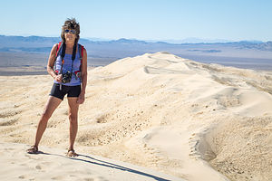 Lolo on Kelso Dune SummitAfter descending and de-sanding ourselves thoroughly, we continued our drive through the Preserve, this time taking the Kelso-Cimo Road northeast back towards I15. At Cima, we bore right onto the Morning Star Mine Road rather than left onto the Cima Road, because a ranger at the Visitor Center warned us that this way would allow us to avoid a very steep section of I15.
As we rose in elevation, we began to see more and more Joshua Trees alongside the road. These trees only grow at above 1,300 feet in the Mojave Desert, so it was kind of cool to see one or two brave ones starting at the lower elevations and then thicker stands of them as we rose even more.
We stopped and took a few photos of them along the way, but we knew that we would have much more opportunity to do that later on during the trip when we visited Joshua Tree National Park.
Description
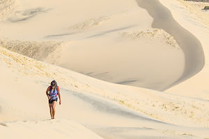 Lolo Hiking up Kelso DuneThe Mojave National Preserve, located in the Mojave Desert between I15 and 140, encompasses 1.6 million acres of sand dunes, Joshua tree forests, wildflowers, and volcanic cinder cones. The Preserve contains three of the four major North American deserts: the Mojave, Great Basin, and Sonoran.
The Preserve was created with the passage of the California Desert Protection Act in 1994, which transferred the lands previously managed by the BLM to the National Park Service.
With elevations in the preserve ranging from 880 feet near Baker to 7,929 feet at Clark Mountain, there is much variety in climate, precipitation, and ecosystems within the Preserve. The best months to visit are October through May, as summer temperatures average from 90 upwards to 105 degrees.
A good way to get an overview of the preserve when traveling between LA and Las Vegas is to exit I15 in the town of Baker, and drive the Kelbaker Road 34 miles south past cinder cones and lava flows to the Kelso Depot Visitor Center. Originally opened as a train station in 1924, Kelso Depot now serves as the Preserve’s visitor center, with exhibits describing its cultural and natural history.
The Kelso Dunes, the second largest dunes in California, are located just a short distance from the visitor center along the well-graded, but unpaved Kelso Dunes Road. The 3-mile round trip hike to the top of the dunes is well worth the effort.
From Kelso, drive north on the Kelso-Cimo Road passing along the Providence Mountains. As you gain elevation, more and more Joshua Trees will appear alongside the road. At Cima, bear right on the Morning Star Mine Road through the Ivanpah Valley and on back to I15, just south of Primm, Nevada.
Camping opportunities in the Mojave National Preserve include roadside camping, backpacking, and two developed campgrounds, both of which are first-come, first-served and have no hookups:
- Hole-In-the-Wall – located at an elevation of 4,400 feet, this campground surrounded by sculptured volcanic rock walls is a great base camp for hikers. There are 35 campsites accommodating RVs and tents.
- Mid Hills – located at an elevation of 5,600 feet, this campground is much cooler than the desert floor below. There are 26 sites. The access road is not recommended for RVs.
There is no lodging or dining within the Preserve.
- ‹ previous
- 4 of 13
- next ›
Mojave National Preserve location map in "high definition"
Javascript is required to view this map.
