- Home
- About
- Map
- Trips
- Bringing Boat West
- Migration West
- Solo Motorcycle Ride
- Final Family XC Trip
- Colorado Rockies
- Graduates' XC Trip
- Yosemite & Nevada
- Colorado & Utah
- Best of Utah
- Southern Loop
- Pacific Northwest
- Northern Loop
- Los Angeles to NYC
- East Coast Trips
- Martha's Vineyard
- 1 Week in Quebec
- Southeast Coast
- NH Backpacking
- Martha's Vineyard
- Canadian Maritimes
- Ocracoke Island
- Edisto Island
- First Landing '02
- Hunting Island '02
- Stowe in Winter
- Hunting Island '01
- Lake Placid
- Chesapeake
- Provincetown
- Hunting Island '00
- Acadia in Winter
- Boston Suburbs
- Niagara Falls
- First Landing '99
- Cape Hatteras
- West Coast Trips
- Burning Man
- Utah Off-Roading
- Maui
- Mojave 4WD Course
- Colorado River Rafting
- Bishop & Death Valley
- Kauai
- Yosemite Fall
- Utah Off-Road
- Lost Coast
- Yosemite Valley
- Arizona and New Mexico
- Pescadero & Capitola
- Bishop & Death Valley
- San Diego, Anza Borrego, Joshua Tree
- Carmel
- Death Valley in Fall
- Yosemite in the Fall
- Pacific Northwest
- Utah Off-Roading
- Southern CA Deserts
- Yosemite & Covid
- Lake Powell Covid
- Eastern Sierra & Covid
- Bishop & Death Valley
- Central & SE Oregon
- Mojave Road
- Eastern Sierra
- Trinity Alps
- Tuolumne Meadows
- Lake Powell Boating
- Eastern Sierra
- Yosemite Winter
- Hawaii
- 4WD Eastern Sierra
- 4WD Death Valley +
- Southern CA Deserts
- Christmas in Tahoe
- Yosemite & Pinnacles
- Totality
- Yosemite & Sierra
- Yosemite Christmas
- Yosemite, San Diego
- Yosemite & North CA
- Seattle to Sierra
- Southwest Deserts
- Yosemite & Sierra
- Pacific Northwest
- Yosemite & South CA
- Pacific Northwest
- Northern California
- Southern Alaska
- Vancouver Island
- International Trips
- Index
- Tips
- Books
- Photos/Videos
- Search
- Contact
Lone Pine - Alabama Hills and Horseshoe Meadow, CA
Wednesday, October 2, 2019 - 12:30pm by Lolo
90 miles and 2.5 hours from our last stop - 2 night stay
Travelogue
Day 1 - Alabama Hills
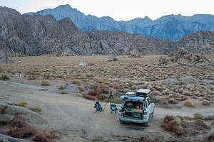 Our camping spot in the Alabama HillsAfter completing our bumping and bouncing on the Papoose Flat 4WD road, we continued down 395 with the intention of camping in the Alabama Hills.
The Alabama Hills is one of our favorite places in the Eastern Sierra. They are both unique and stunningly beautiful, with hundreds of oddly-shaped boulders and towers set against the backdrop of Mount Whitney (the tallest mountain in the continental U.S.).
For people our age, some of the scenery in the Hills might even be familiar from watching old Westerns. Hollywood filmmakers discovered this dramatic scenery back in the 1920s and filmed hundreds of movies (particularly westerns), TV shows, and commercials here, such as “How the West was Won,” “Rawhide,” and “Gunga Din.” And, it’s not just about old westerns. Plenty of current day movies, such as “Gladiator,” “Django Unchained,” and the new Lone Ranger have used the surrounding hills as a set as well.
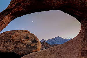 Moonrise through Mobius ArchThere’s a wonderful Film History Museum in Lone Pine where you can learn all about the film history of the area. They also provide a “Movie Road Touring Brochure” that has a detailed map of the nearby 5.7-mile unpaved Movie Flat Road (2WD friendly) that shows where many of these movies were filmed.
Normally, people get to Movie Flat Road by driving into the town of Lone Pine and turning onto the Whitney Portal Road. We, however, were familiar with the area, so instead of going all the way into town, we turned off 395 onto the Moffat Ranch Road on the northern end of the Alabama Hills, and started looking for a good place to camp for the night. We pulled into what we thought was a nice spot, surrounded by cottonwood trees and shrubs, but we soon found out that the reason there was so much greenery here was that there was water, and where there is water, there are bugs.
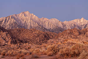 Good morning Mt. WhitneyRather than going back onto 395, we continued south along the dirt roads through the Hills, eventually finding a nice spot to camp right off Movie Flat Road near the iconic Mobius Arch, where photographers love to photograph Mount Whitney framed by the arch. Of course, we have taken this photo in the past and will most likely do so again. Each photo can be different, based on weather conditions and time of day.
Herb said up his tripod to photograph Whitney and the surrounding peaks in the evening light, while I set off on a walk to visit Mobius Arch, planning to get back before it got totally dark. The trailhead was just a hundred yards away.
The first arch I came to was the less famous, but equally interesting, Lathe Arch, a rather unique arch in that it is perfectly flat and really doesn’t arch at all.
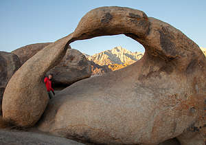 Lolo unknowingly walking into my shot of Mobius ArchJust past Lathe Arch, I rounded a big rock and came upon Mobius Arch, which at this hour I had all to myself, so I could take my time composing a photo rather than waiting in line, as can happen here. I tried to get Mt. Whitney framed within the arch and the rising crescent moon above. Not bad, but probably would have been a lot better if I had a tripod, rather than just a cellphone.
It was getting pretty dark, so I picked up the pace a bit to get back to camp. I thought that the only trail here was the Mobius Arch Loop and couldn’t possibly get lost, but I have amazingly poor navigational skills, and wound up adding a mile to my .6 mile hike by veering off onto the Alabama Hills Trail. Fortunately, I could see the 4Runner and Herb off in the distance and was able to get back before he started to worry too much about his navigationally-challenged spouse.
The next morning, Herb got up before 6:00 to take photos of the sunrise by Mobius Arch. I dragged myself out of the truck about a half hour later and walked over to try to find him. I think I surprised him as I climbed up the back side of Mobius Arch and popped up into the window of the arch through just as he was taking a photo of Mount Whitney through it from the other side. See, I said every photo of Mobius Arch can be different.
Day 2 - Horseshoe Meadows
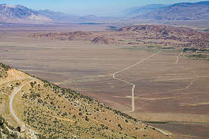 The road up to Horseshoe MeadowHorseshoe Meadows was another discovery I had made when reading the “Tales Along El Camino Sierra” book that Andrew and Celeste had given me for Christmas. It’s an easy, delightful read about the people and places that over the last century have made Highway 395 (alias El Camino Sierra) such a special place.
In this book, I learned how this amazing zigzagging road, blasted out of granite rock came to be.
As I mentioned in the Bishop stop, in the early 1900s, the Inyo Good Roads Club began promoting the beauty and recreational opportunities of Inyo County and were able to obtain federal dollars to build roads.
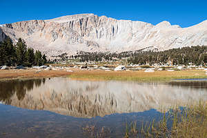 The first of many lakes on the Cottonwood Lakes hikeOne of the more ambitious road projects they came up with in the 1920s was building a 20-mile road up to Horseshoe Meadows, high above Lone Pine, at an elevation of 10,000 feet, which would make it the second highest paved road in California.
The LA Department of Water & Power, in their endless quest for water for their growing city, saw potential in the Horseshoe Meadows area, and joined in the effort. However, road-building technology of that day was not equipped to deal with such serious mountain terrain, so construction was stopped after 5 miles of road were completed - far short of their goal.
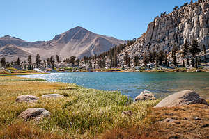 Along the Cottonwood Lakes TrailIt wasn’t until 1964 that Inyo County resumed work and built another 6.7 miles, still a few miles short of the meadow. Then in the late 1960s, the U.S. Forest Service initiated an effort to develop the Horseshoe Meadows area as a ski resort, and the road was completed. Cooler headers realized that this was not feasible, and the ski resort was never built.
Today, Horseshoe Meadows is a serene and lightly visited paradise with access to some of the most sublime scenery in the southern Sierra - and that was where we planned to spend our day.
The Horseshoe Meadow Road begins about 3 miles along the Whitney Portal Road and climbs and climbs for the next 20 miles, from 3,727 feet in Lone Pine up to 10,072 feet. Along the whole drive, we could see the road ahead of us, steeply zigzagging its way up the mountain.
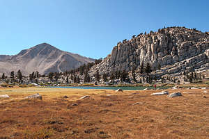 Cottonwood Lakes TrailWe parked in the Cottonwood Lakes Trailhead parking area near the end of the Horseshoe Meadow Road and set out on what was probably one of the nicest hikes we’ve ever been on.
For the first few miles, we hiked through a sandy pine forest, and although it consistently climbed, it did so at a pretty gentle grade. At 3.7 miles we came to a junction - Cottonwood Lakes to the right and New Army Pass Trail to the left.
We took a right, and after about a mile we came to the first of the beautiful Cottonwood Lakes. Later we found out that we actually took the loop in the reverse direction and hit the rather mundanely named Cottonwood Lake #3, Cottonwood Lake #2, and Cottonwood Lake #1, in that order at the end.
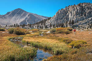 Further along the Cottonwood Lakes TrailWell, I don’t care what number this lake was, because it was absolutely beautiful, with the backdrop of the Sierra behind it, as well as reflected in the lake. I looked at the Forest Map for this hike afterwards and see that this is Unnamed Lake. Perhaps its beauty left them speechless.
We continued on and eventually came to Cottonwood Lake #3. We followed a path down to its western shoreline and had lunch. Herb’s Garmin G5X watch, which has trails loaded onto it, showed a trail along the northern shore of the lake that would bring us to Cottonwood Lake #2.
However, there was no such trail, so we improvised and had to bushwhack (although thankfully, there were no bushes) a bit to get to a sort of trail between Cottonwood Lake #2 and #1. Each lake was different and beautiful in its own way.
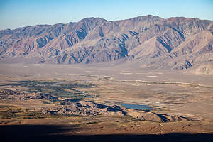 Looking down on the Alabama Hills from Horseshoe Meadow RoadWe found the main trail and hiked back down through the lovely pine forest to our car.
All in all, we hiked 13 miles with an elevation gain of 1,500 feet, my third hike over 11,000 feet this week, and this time zero altitude sickness.
Rather than disperse camp in the Alabama Hills again that evening, we decided to live it up and stay at the Tuttle Creek Campground (elevation 4,944 feet), just off the Horseshoe Meadow Road back near Lone Pine. Like our campsite last night, it too had beautiful views of Mt. Whitney and the surrounding Sierra.
The Cottonwood Lakes hike is definitely worth a repeat, especially since I read afterwards that Cottonwood Lake #4 and #5 are the most beautiful, and we never got to those. I’m not sure how they could have been any better, but someday we’ll just have to find out.
Description
The Lone Pine Film History Museum houses memorabilia from the hundreds of films, commercials, and television shows that were filmed in the nearby area over the past 100 years. Since the early years of filmmaking, directors and actors have made the 3-hour trek from Hollywood to the tiny town of Lone Pine to use the dramatically beautiful Alabama Hills as the backdrop for their films. Although mostly known for the “westerns” filmed here, with such cowboy heroes as John Wayne, Gene Autry, and Roy Rogers, it has also been the site for early silent, post-war, and science fiction films. The museum has an 85-seat movie theater where visitors can watch an interesting 15-minute documentary, “Lone Pine: Where the Real West Becomes the Reel West.” Admission is $5 for adults.
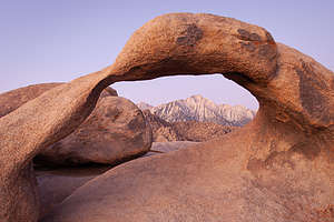 Mt. Whitney through Mobius ArchThe Alabama Hills are a range of hills and rock formations, just west of Lone Pine, that lie at the foot of the eastern Sierra Nevada Mountains. Mount Whitney, the tallest mountain in the continental U.S., towers over the hills. Although the same age as the sharp, glacially chiseled ridges of the Sierra, the Alabama hills are more rounded as a result of chemical weathering. When the hills were still covered with soil, percolating water rounded the granite blocks and sculpted the interesting arches and potato-shaped boulders you see today. These interesting formations make it a popular rock climbing destination.
The outstanding and dramatic scenery of the hills has also attracted Hollywood filmmakers from the 1920s to the present. Hundreds of movies (particularly westerns), TV shows, and commercials have been filmed here over the past century. The Lone Pine Film History Museum is a great place to learn about the film history of the area. The 5.7-mile unpaved Movie Flat Road through the Hills goes past the filming locations for such greats as “How the West was Won,” “Rawhide,” and “Gunga Din.” A “Movie Road Touring Brochure,” is available online or at the museum.
The origin of its name is quite interesting and surprising. In the 1800s, prospectors in the area sympathetic to the Confederate cause named their mining claims after the confederate warship Alabama, which was wreaking havoc on the Union fleet.
Whitney Portal is the gateway to Mount Whitney, the tallest mountain in the continental U.S., and the main starting point for treks up to its summit. It is located at the end of the 13-mile Whitney Portal Road, which begins from 395 in the town of Lone Pine. Although hiking into the Mount Whitney Zone requires a permit, there are several day hikes that can be done within the John Muir Wilderness section without a permit, such as the hike to Lone Pine Lake.
The Manzanar National Historic Site marks the site of the former Manzanar Relocation Center, one of ten internment camps into which the U.S. government forcefully interned more than 110,000 Japanese American citizens during World War II. The Manzanar facility operated from March of 1942 through November of 1945, housing and holding without their will over 10,000 Japanese Americans. Today this site, which is preserved and operated by the National Park Service, informs visitors about the legacy of this shameful period in U.S. history. Inside the Visitor Center there are extensive exhibits as well as a 22-minute informative film. Adjacent to the Visitor Center are two reconstructed barracks and a mess hall, the only three original camp structures that remain. A 3.2 mile auto tour takes you past remnants of orchards, gardens, and building foundations, as well as the camp cemetery, located at the foot of the majestic Sierra. Admission is free.
- ‹ previous
- 3 of 5
- next ›
Lone Pine - Alabama Hills and Horseshoe Meadow location map in "high definition"
Javascript is required to view this map.
