- Home
- About
- Map
- Trips
- Bringing Boat West
- Migration West
- Solo Motorcycle Ride
- Final Family XC Trip
- Colorado Rockies
- Graduates' XC Trip
- Yosemite & Nevada
- Colorado & Utah
- Best of Utah
- Southern Loop
- Pacific Northwest
- Northern Loop
- Los Angeles to NYC
- East Coast Trips
- Martha's Vineyard
- 1 Week in Quebec
- Southeast Coast
- NH Backpacking
- Martha's Vineyard
- Canadian Maritimes
- Ocracoke Island
- Edisto Island
- First Landing '02
- Hunting Island '02
- Stowe in Winter
- Hunting Island '01
- Lake Placid
- Chesapeake
- Provincetown
- Hunting Island '00
- Acadia in Winter
- Boston Suburbs
- Niagara Falls
- First Landing '99
- Cape Hatteras
- West Coast Trips
- Burning Man
- Utah Off-Roading
- Maui
- Mojave 4WD Course
- Colorado River Rafting
- Bishop & Death Valley
- Kauai
- Yosemite Fall
- Utah Off-Road
- Lost Coast
- Yosemite Valley
- Arizona and New Mexico
- Pescadero & Capitola
- Bishop & Death Valley
- San Diego, Anza Borrego, Joshua Tree
- Carmel
- Death Valley in Fall
- Yosemite in the Fall
- Pacific Northwest
- Utah Off-Roading
- Southern CA Deserts
- Yosemite & Covid
- Lake Powell Covid
- Eastern Sierra & Covid
- Bishop & Death Valley
- Central & SE Oregon
- Mojave Road
- Eastern Sierra
- Trinity Alps
- Tuolumne Meadows
- Lake Powell Boating
- Eastern Sierra
- Yosemite Winter
- Hawaii
- 4WD Eastern Sierra
- 4WD Death Valley +
- Southern CA Deserts
- Christmas in Tahoe
- Yosemite & Pinnacles
- Totality
- Yosemite & Sierra
- Yosemite Christmas
- Yosemite, San Diego
- Yosemite & North CA
- Seattle to Sierra
- Southwest Deserts
- Yosemite & Sierra
- Pacific Northwest
- Yosemite & South CA
- Pacific Northwest
- Northern California
- Southern Alaska
- Vancouver Island
- International Trips
- Index
- Tips
- Books
- Photos/Videos
- Search
- Contact
Lake Powell - Halls Creek Bay, UT
Wednesday, July 4, 2018 - 9:45pm by Lolo
63 miles and 3.5 hours from our last stop - 2 night stay
Travelogue
Day 1 - Hole-in-the-Rock and Lagorce Arch
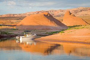 Our campsite in Halls Creek BayMorning hike complete and anchors stowed, we continued our journey north towards Halls Creek, with a few diversions along the way.
At Buoy 66, we stopped at Hole-in-the-Rock, the site of one of the most daring and difficult journeys ever made during the pioneer days - and that is saying a lot. In October of 1879, a party of 230 Mormons, 83 wagons, and 1,000 cattle were sent out to build a settlement on the San Juan River. Their journey brought them to Panguitch, Escalante, down what is today known as the Hole-in-the-Rock, a narrow and steep crevice in the western rim of Glen Canyon.
The pioneers spent the winter working on the crack, slowly enlarging the opening with only pick axes, shovels, and small supplies of blasting powder. The drop to the river below was nearly 2,000 feet with an average grade of 25 degrees, although some places were as steep as 45 degrees.
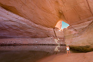 Lagorce ArchFinally, on January 26, 1880, the expedition slowly made its way down the precarious “road” where a ferry had been built to get them across to the eastern side of the Colorado River where there was a route for them to continue on.
Although one-third of the trail is now under water, the rest is still visible. Staring up at that steep crevice, I had a hard time imagining how they had accomplished this amazing feat.
At Buoy 68, we took a short diversion up a portion of the Escalante Arm to Davis Gulch, a deep, narrow canyon that meanders for two miles before reaching Lagorce Arch, a huge natural window, 100 feed wide and 75 feet high. Fortunately lake levels were just high enough to reach the arch, but things dried up right afterwards. It was eerily quiet and quite impressive.
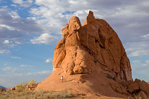 Lolo exploring rocks around Halls Creek BayBack on the main channel (Colorado River) again, we continued up to Halls Crossing where we gassed up at the marina.
From there we crossed back over to Halls Creek (Buoy 93), a large bay barely noticeable from the main channel because of its narrow opening. Along its 12 miles, there are innumerable coves that cut into the southernmost toe of 100-mile long Waterpocket Fold, many of which have sandy beaches for camping.
We managed to find a nice quiet home for the night in a shallow cove, hopefully too small for houseboats to join us. The scenery was incredible and there was much more opportunity to hike for longer distances than we had been able to so far at our previous camping spots - good, because I was beginning to feel a little confined on the boat, and then I get cranky.
We were getting in a groove now - cruise in the morning, find camping early afternoon, swim / float, and then hike when the sun got low. That evening, we took a lovely hike and once again slept under the stars in the back of our boat.
Day 2 - Defiance House Ruins
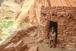 Defiance House RuinsThe next morning, before departing, we went on another hike before it got prohibitively hot, which unfortunately was by 8 am.
After a quick dip, we pulled up anchor and headed out of Halls Creek Bay and then north on the main channel to Forgotten Canyon (Buoy 106), at the end of which was a hike to the Defiance House Ruin, an Anasazi dwelling more than 700 years old.
We anchored when the water ran out, and then trudged through some muck before getting to the main trail. It was a bit confusing, and soon we found ourselves bushwhacking through high grass and weeds. I hate to admit it, but we had missed the turnoff for the ruins, and only realized it when we heard voices coming from high up on the canyon wall.
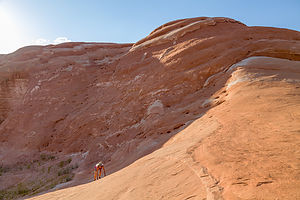 Playing on the Waterpocket FoldBack we went, taking the established trail up a series of switchbacks to the ruins on a shelf on the canyon wall. The site consisted of two dwellings, a ceremonial kiva, and several kitchen pits, which have been restored by the National Park Service. However, by far my favorite was the large pictograph of three warriors “defiantly” (hence the name) waving their clubs and shields in an apparent duel. They were even anatomically correct.
That was as far north as we planned to go, so after leaving Forgotten Canyon, we headed back south, peaking into several canyons in search of a good camping spot. Everything seemed to already be occupied by houseboats, so we decided to go back to the same place we camped last night, hoping that our theory that it was too small for a houseboat was correct. It was, and we settled in there for another night.
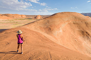 Waterpocket Fold near our campsite on Halls Creek BayThen it was swim and hike again when the sun got low. Fortunately, there was enough open spaces and rocks to scramble up to make each hike somewhat unique.
I realized I haven’t mentioned yet what we were eating for dinner. We had some backpacking freeze dried dinners like Lasagna and Chicken Alfredo, but what we found we like much better was Knorr’s soup with either some packaged tuna, salmon, or chicken thrown in. All of this was done in a single pot on a Jetboil, which we ate directly ate out of - no muss, no fuss. It was actually quite good. Perhaps, the wine helped.
- ‹ previous
- 4 of 6
- next ›
Lake Powell - Halls Creek Bay location map in "high definition"
Javascript is required to view this map.
