- Home
- About
- Map
- Trips
- Bringing Boat West
- Migration West
- Solo Motorcycle Ride
- Final Family XC Trip
- Colorado Rockies
- Graduates' XC Trip
- Yosemite & Nevada
- Colorado & Utah
- Best of Utah
- Southern Loop
- Pacific Northwest
- Northern Loop
- Los Angeles to NYC
- East Coast Trips
- Martha's Vineyard
- 1 Week in Quebec
- Southeast Coast
- NH Backpacking
- Martha's Vineyard
- Canadian Maritimes
- Ocracoke Island
- Edisto Island
- First Landing '02
- Hunting Island '02
- Stowe in Winter
- Hunting Island '01
- Lake Placid
- Chesapeake
- Provincetown
- Hunting Island '00
- Acadia in Winter
- Boston Suburbs
- Niagara Falls
- First Landing '99
- Cape Hatteras
- West Coast Trips
- Burning Man
- Utah Off-Roading
- Maui
- Mojave 4WD Course
- Colorado River Rafting
- Bishop & Death Valley
- Kauai
- Yosemite Fall
- Utah Off-Road
- Lost Coast
- Yosemite Valley
- Arizona and New Mexico
- Pescadero & Capitola
- Bishop & Death Valley
- San Diego, Anza Borrego, Joshua Tree
- Carmel
- Death Valley in Fall
- Yosemite in the Fall
- Pacific Northwest
- Utah Off-Roading
- Southern CA Deserts
- Yosemite & Covid
- Lake Powell Covid
- Eastern Sierra & Covid
- Bishop & Death Valley
- Central & SE Oregon
- Mojave Road
- Eastern Sierra
- Trinity Alps
- Tuolumne Meadows
- Lake Powell Boating
- Eastern Sierra
- Yosemite Winter
- Hawaii
- 4WD Eastern Sierra
- 4WD Death Valley +
- Southern CA Deserts
- Christmas in Tahoe
- Yosemite & Pinnacles
- Totality
- Yosemite & Sierra
- Yosemite Christmas
- Yosemite, San Diego
- Yosemite & North CA
- Seattle to Sierra
- Southwest Deserts
- Yosemite & Sierra
- Pacific Northwest
- Yosemite & South CA
- Pacific Northwest
- Northern California
- Southern Alaska
- Vancouver Island
- International Trips
- Index
- Tips
- Books
- Photos/Videos
- Search
- Contact
Kancamagus Highway, NH
Tuesday, February 22, 2000 - 7:00am by Lolo
235 miles and 5 hours from our last stop
Travelogue
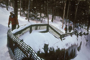
 Lolo and Boys on Sabbaday Falls HikeSince all highways from Maine seem to go north-south rather than east-west, the only way to get across to Vermont was via back roads, which was fine with us. Thankfully, it wasn't snowing. Also, since we had our high-tech laptop / GPS setup, we felt pretty confident that we would find a good route and not get lost. Generally, that was the case. However, in Poland Spring, Maine (the place of bottled water fame), our trusty GPS took it upon itself to find a short cut--I can still remember the name, Quarry Road. Unfortunately that shortcut was a bumpy, dirt road, so narrow that we could barely turn around on it once we realized how foolish a move this was. It just goes to show you that computers don't know everything.
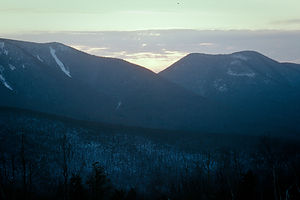
 Herb and sunset over the KancOnce back on the asphalt, we continued west across New Hampshire via the Kancamagus Highway, more affectionately known as "The Kanc." This road runs for 34 scenic miles through the White Mountains from Conway to Lincoln. The views along the way were breathtaking. We stopped at the Sabbaday Falls Picnic Area and took the short hike up through a forest to the waterfalls. There was lots of snow. At first, we tried to tell the boys to stay on the trail and not get wet because we had no way to dry their clothes in the RV. However, we soon realized that telling 8 and 10 year old boys to stay out of the snow was futile. Those clean white piles of snow were just too tempting.
By the time we got back to the RV, the sun was already beginning to set over the White Mountains. It was absolutely beautiful. However, it was time to get moving--we still had another 3 hours of driving to get to our campground in Vermont."
Description
 Views from Kancamangus HighwayThe Kancamagus Highway, affectionately referred to as "The Kanc," runs for 34 scenic miles through the White Mountains of New Hampshire from Conway west to Lincoln. During that stretch, it crosses several mountains, the highest of which is Mount Kancamagus. The views along the way are breathtaking. The most scenic portion of the road is the 3 miles between the White Mountain National Forest and the town of Lincoln, on the western end of the road.
A great place to stop and stretch your legs is the Sabbaday Falls Picnic Area, alongside the Swift River. This is also the trailhead for one of the most popular family hikes along the Kanc--the .4-mile hike to the narrow flume and picturesque Sabbaday Waterfall."
- ‹ previous
- 3 of 9
- next ›
Kancamagus Highway location map
Javascript is required to view this map.
