- Home
- About
- Map
- Trips
- Bringing Boat West
- Migration West
- Solo Motorcycle Ride
- Final Family XC Trip
- Colorado Rockies
- Graduates' XC Trip
- Yosemite & Nevada
- Colorado & Utah
- Best of Utah
- Southern Loop
- Pacific Northwest
- Northern Loop
- Los Angeles to NYC
- East Coast Trips
- Martha's Vineyard
- 1 Week in Quebec
- Southeast Coast
- NH Backpacking
- Martha's Vineyard
- Canadian Maritimes
- Ocracoke Island
- Edisto Island
- First Landing '02
- Hunting Island '02
- Stowe in Winter
- Hunting Island '01
- Lake Placid
- Chesapeake
- Provincetown
- Hunting Island '00
- Acadia in Winter
- Boston Suburbs
- Niagara Falls
- First Landing '99
- Cape Hatteras
- West Coast Trips
- Burning Man
- Utah Off-Roading
- Maui
- Mojave 4WD Course
- Colorado River Rafting
- Bishop & Death Valley
- Kauai
- Yosemite Fall
- Utah Off-Road
- Lost Coast
- Yosemite Valley
- Arizona and New Mexico
- Pescadero & Capitola
- Bishop & Death Valley
- San Diego, Anza Borrego, Joshua Tree
- Carmel
- Death Valley in Fall
- Yosemite in the Fall
- Pacific Northwest
- Utah Off-Roading
- Southern CA Deserts
- Yosemite & Covid
- Lake Powell Covid
- Eastern Sierra & Covid
- Bishop & Death Valley
- Central & SE Oregon
- Mojave Road
- Eastern Sierra
- Trinity Alps
- Tuolumne Meadows
- Lake Powell Boating
- Eastern Sierra
- Yosemite Winter
- Hawaii
- 4WD Eastern Sierra
- 4WD Death Valley +
- Southern CA Deserts
- Christmas in Tahoe
- Yosemite & Pinnacles
- Totality
- Yosemite & Sierra
- Yosemite Christmas
- Yosemite, San Diego
- Yosemite & North CA
- Seattle to Sierra
- Southwest Deserts
- Yosemite & Sierra
- Pacific Northwest
- Yosemite & South CA
- Pacific Northwest
- Northern California
- Southern Alaska
- Vancouver Island
- International Trips
- Index
- Tips
- Books
- Photos/Videos
- Search
- Contact
Eastern Sierra (South of Mono Lake), CA
Tuesday, August 26, 2014 - 1:00pm by Lolo
260 miles and 6 hours from our last stop - 3 night stay
Travelogue
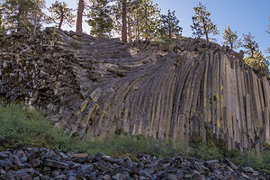 Devils PostpilesAlthough we had been to Mono Lake before, we had never explored the Eastern Sierra in any depth, so we decided it was definitely time to fill in this gap in our western travels.
Rather than drag the motorhome along for each of our stops, we decided to set up base camp at the Mammoth Mountain RV Park in Mammoth Lakes and set out on day trips in our Subaru. Towing a car has definitely been a very liberating experience.
The drive out through the very steep Tioga Pass had been a bit stressful, to say the least, with the uncertainty of the status of our brake calipers, so when we got to the campground, we decided to just relax there for the remainder of the day. Also, this was the first time that we had access to a laundry in two weeks, so hanging out in the hot tub in between wash loads was about all the physical activity we were up for today.
Devils Postpile National Monument and the Ancient Bristlecone Pine Forest
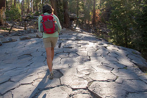 Lolo Hiking on Top of Devils PostpilesHowever, the next morning we were refreshed and ready to see new sights. Our first destination was the nearby Devils Postpile National Monument, an unusual rock formation comprised of hexagonal basalt columns. From mid-June through mid-September, cars are not allowed into the Monument after 7:00 am, and visitors must take a shuttle bus from the Mammoth Mountain Adventure Center. We briefly toyed with getting up early enough to drive into the park, but then we came to our senses and decided to take the shuttle instead. The tickets were only $7 and the bus driver gave an interesting talk and pointed out things to see along the way, such as the impressive Minarets.
The shuttle has about 10 stops in the park, but we got out at the Devils Postpile Ranger Station (Stop 6) near the trailhead for the Devils Postpile and Rainbow Falls.
From the trailhead, we walked along a very pleasant, level path that traced a section of the Middle Fork of the San Joaquin River. In less than a half mile, we came upon the Postpile, which definitely was different from any rock formation we had ever seen. Probably the closest thing to them that we have seen are the basalt cliffs along the Columbia River Gorge.
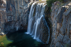 Rainbowless Falls at Devils Postpile National MonumentThe columns were so uniform that they really appeared to be man-made rather than by the forces of nature. But as we have learned over and over again in our travels, nature has created some pretty miraculous sights. These uniformly-shaped basalt columns were formed over 80,000 years ago when basalt lava erupted in the area, cooled, contracted, and split into symmetrical, hexagonal columns, one of mother nature’s favorite shapes.
The view from the top of the cliff, which you can reach by walking up a short, steep trail around the back, really accentuates their hexagonal shapes and made me even more amazed that they were created through a natural process. It looked like someone had laid down hexagonal floor tiling, with the occasional pentagonal tile thrown in here and there.
From there we hiked back down the formation and continued along the trail another 2 miles until we reached Rainbow Falls, where the San Joaquin River plunges 101 feet over a cliff of volcanic rock. The falls got its name from the rainbows that sparkle in the mist when the sun is overhead.
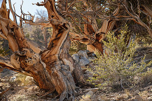 Bristlecone Pine TreesUnfortunately, we were here too early in the morning to have the proper lighting either on the falls or on the Devils Postpile. We thought about waiting around until the afternoon so that we could get better lighting for photographs, but decided that instead we would rive down to Big Pine to hike through the Ancient Bristlecone Pine Forest.
So, we hiked back to the Red Meadow Shuttle Stop and returned by shuttle to the Mammoth Mountain Adventure Center.
The drive to Big Pine took us along the Eastern Sierra Scenic Byway (US 395) through the quaint town of Bishop, where we had stopped back in 2007 to visit the very impressive Galen Rowell photography gallery. This time we would visit an equally impressive Bishop establishment, the Erick Schat’s Bakery, known for its delicious pastries and other baked goods. We were only three feet in the door before I picked up an Apple Pullover, the size of a football, to purchase. Funny, how when driving into town, I thought how quiet it was. Now I know why –everyone was in this bakery. It was absolutely bustling. We bought two sandwiches made with their famous sheepherder bread and ate them on the outside patio.
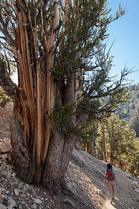 Lolo Hiking in Bristlecone Pine ForestFrom there, we continued on US 395 south to the town of Big Pine and turned east on State Highway 168. After 13 miles, we turned left onto White Mountain Road and followed that for another 10 miles to the Schulman Grove Visitor Center. We were very grateful we were in our Subaru rather than the motorhome, because the road was very steep and windy. We stopped at an incredible viewpoint just about a mile shy of the top.
From the Schulman Visitor Center, we took the Methuselah Trail, named for the oldest documented living tree in the world which lives along this trail. It is estimated to be over 4,750 years old. Unfortunately, although we would most likely see it, we wouldn’t know when, because its location is kept a secret, for fear that someone might cut it down or harm it in some way. How sad is that?
The trail was lovely, winding its way for 4 ½ miles through bristlecone pines, both ancient and new – some of the baby ones were probably only about a thousand years old. These trees were very photogenic, each of them individually sculpted by thousands of years of wind, ice, and extreme exposure to the elements. Their twisted and contorted shapes are evidence of their ability to not only survive, but to thrive in adverse living conditions. It’s funny how the harshest growing conditions produce trees that live the longest. There’s much to be said for tough love.
It had been quite a robust day, with hikes in two very interesting and unique areas.
Mammoth Mountain Bike Park and Inyo Craters
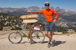 Herb with GoPro at Trail Juncture in Mammoth Mountain Bike ParkOur boot camp of a vacation continued the next day with plans to mountain bike down the trails of Mammoth Mountain. I was definitely going to need a vacation from this vacation.
We drove the short distance from our campground to the Mammoth Mountain Adventure Center and purchased our Bike Park tickets. Our choices were $41 for two rides down the mountain, or $49 for all day. Of course, the economically minded Herb went for the $49 value and planned to make the most of it.
There was nobody there, so we able to get on a Panorama Gondola right away. You could tell from the set up though that they were prepared to handle a crowd. The very courteous liftees took our bikes and loaded them on a gondola for us, and then we got in the one behind. The views from the gondola were awesome. Why couldn’t we just ride this thing up and down all day? – I didn’t say that aloud, but I did think it. At the top, the liftees politely removed our bikes from their gondola and set us on our way. Very civilized so far.
We were now atop the summit of Mammoth Mountain at an elevation of 11,053 feet, where the 360 degree views were incredible. I think I could see all of California from here. I took note of the Top of the Sierra Café where I intended to reward myself with lunch if I made it back up here again.
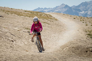 Lolo on Inadequate Hardtail BikeWe rolled our bikes down the staircase from the gondola – the cool kids ride them down, but I was just getting warmed up. The cool kids also wear full-body armor and ride full-suspension bikes. I was a 58-year-old woman in a running outfit wondering what the heck I was doing up here.
There were two choices of trails from the summit – Kamikaze and Off the Top. Little hint: If you are at a trail junction, and one of the trail names is Kamikaze, take the other one, which we smartly did. Off the Top was a blue, intermediate trail as opposed to a black diamond. Mountain bike parks rate the difficulty of their trails the same way ski slopes do.
Herb let me go first so he could keep an eye on me – actually not just an eye, but a camera. He GoPro’d my entire first descent – all 10 miles and 1 hour of it. I watched the entire thing afterwards, and am sure that I am the only one that ever will. I was both impressed and amused by my efforts.
The trail was quite steep, but not ridiculously so, and wound its way along dozens of switchbacks for most of the first five miles. We were above the tree-line, so we were on exposed mountainside with uninterrupted views, which I would have seen if I ever took my eyes off my front tire.
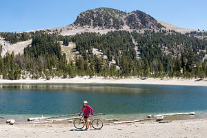 Lolo and Lake in Mammoth Mountain Bike ParkAt a trail junction, we continued on another blue trail called Beach Cruiser which flattened out for awhile and brought us to a pretty little lake, called Bud Lake. Afterwards, the trail led through a lovely forest of trees, where we even had to peddle uphill at times.
We made it back to the gondola after about an hour, with no cuts or bruises. Proudly, neither of us had taken a spill.
Still no crowds, so we were able to just hop back on the gondola again. The same guy loaded our bikes on the gondola. I think he was pretty surprised to see that the old lady was back for more.
At the top, I suggested lunch, but Herb, wanting to make sure that we got our money’s worth out of our All-Day pass, suggested that we eat after the next run, thereby guaranteeing that I would have to go for a third.
I reluctantly agreed, and we set off again, this time taking a different trail near the bottom, which brought us to wonderful views of the Minaret pinnacles. The second run was a bit easier, because I knew what to expect, but I was getting a little tired. You would think that going downhill isn’t tiring, but it actually is very tough on the arms and the hands, which in my case were desperately gripping the brakes. Also, even the legs get tired because you have to hold yourself up off the seat most of the way.
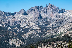 Minarets ViewpointSoon, we were on our way up for our third, and what I was suggesting, final run. As promised, Herb did take me to lunch at the Top of the Sierra Café first. By the time we finished lunch, the winds had picked up and were really gusting. I honestly was a bit concerned about being blown over. I didn’t need any more challenges getting through the switchbacks at the top.
I was really pretty tired now and on one of the early switchbacks, I almost did an “endo” – where I braked so hard that the back of my bike lifted up too high and almost sent me over my handlebars. Herb was way ahead. I had told him to go first, because I was much slower, but still I was mad at him now because I was scared and he wasn’t by my side.
From this point on I was totally psyched out, which is very bad, because you really have to ride with confidence to get through this stuff. While I hadn’t fallen at all the first two runs, I must have fallen about 4 or 5 times on this one. It was getting to a point where I would practically throw myself on the ground rather than wait for the bike to do that for me. I even landed in a very cute pine tree. Herb later said that I probably killed a thousand year old bristlecone pine, because they actually do grow on the mountainside. I didn’t care. It deserved it.
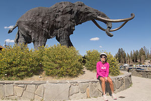 Lolo with MammothHerb knew he was in trouble when I caught up with him at the bottom, scratched, bloody, and tearful. Two runs would have been great, but three had really pushed me over the top. We had ridden over 30 miles of some very steep and rough terrain. I had every right to be cranky.
Before returning my weary body to the much-needed hot tub at the campground, we decided to make a quick stop at the nearby Inyo Craters, right off the Mammoth Scenic Loop .
Herb and I had definitely developed, rather late in our national park travels, a keen interest in geology. A few years back, Herb and I discovered TTC (The Teaching Company) videos of various college courses. Every morning after breakfast, we dutifully sit down with a cup of coffee and watch a ½-hour lecture on a particular subject. Last year we completed two entire courses on geology (18 hours each), and are always anxious to go out and apply what we have learned. Tommy’s move to the Pacific Northwest and its many volcanoes features definitely gives us plenty of opportunity to do just that.
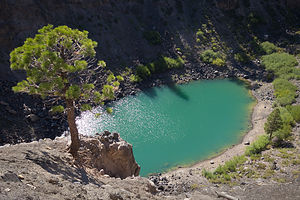 Inyo CraterOnce we found the Inyo Craters parking lot at the end of a dirt road off the Scenic Loop, it was just a 1/4-mile walk through a lovely forest to get to the rim of the first of the Inyo Craters. This crater is part of a 25- mile chain of craters that stretches from here all the way to Mono Lake.
This crater and the next one, which is only a short walk away, are about 660 feet across and contain small lakes. The water in them was a beautiful, deep turquoise. There was an observation area even closer to the rim, but because of erosion, access to it was blocked off.
In terms of geological time, these craters were very young – only 600 years old, babies compared to the bristlecone pines we saw the other day. They were formed when magma pushed up into the water table, heated it, and triggered a volcanic phreatic (fancy word for steam) explosion on the summit and south flank of Deer Mountain. The two craters we visited were the ones along the south flank.
We returned to the campground, got a cooler of cold beer, and went and sat it the campground hot tub. It was the right thing to do.
Description
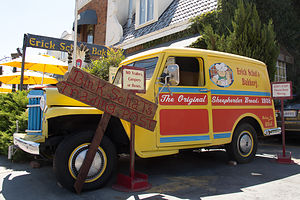 Erick Schat’s Bakery TruckThe Eastern Sierra Scenic Byway, officially known as Highway 395, runs the entire length of the Sierra Nevada Range, from south of Lone Pine to Carson City. The scenery along the way is breathtaking and full of variety – snow covered mountains, incredible lakes, ancient bristlecone forests, natural hot springs, and so much more.
I have broken up our journey along the Scenic Byway into three stops:
• South of Mono Lake
• Mono Lake
• North of Mono Lake
The following is a description of a few of the stops we enjoyed along the Eastern Sierra southern section:
Devils Postpile National Monument
Devils Postpile National Monument, located near Mammoth Mountain, was created in 1911 to protect a premier example of columnar basalt formations and the 101-foot Rainbow Falls. It was originally part of Yosemite National Park, but when gold was discovered near Mammoth Lakes in 1905, local mining interests pressured the government to make it public land so that they could build a hydroelectric dam. Their plans were to dynamite the postpile to make a rock dam. Thankfully, environmental activists, such as John Muir, were able to stop the demolition and bring the area back under federal protection as a National Monument.
The main attraction in the Monument is a dark 60-foot cliff of uniformly-shaped basalt columns. These columns were formed approximately 82,000 years ago when basalt lava erupted in the area. As the lava cooled, it contracted and split into symmetrical, hexagonal columns. Then, around 12,000 years ago, a glacier carved away one side of the postpile, polishing the top and exposing the sheer wall of columns that you see today.
A second attraction is Rainbow Falls, where the Middle Fork of the San Joaquin River plunges 101 feet over a cliff of volcanic rock. It received its name from the rainbows that sparkle in the mist when the sun is overhead.
Between June 15 and September 15, the park is closed to daytime traffic and requires visitors to travel by shuttle from the Mammoth Mountain Adventure Center.
Mammoth Mountain Bike Park
The Mammoth Mountain Bike Park boasts over 80 miles of single track trails for riders of every experience level. Beginners can start at the Discovery Zone where there are miles of forested intermediate Cross Country trails. The more experienced can take the Panorama Gondola to either the mid-station or the summit for intermediate to advanced terrain.
Mammoth Mountain was rated the #1 bike park in the U.S. by Outside Magazine.
Inyo Craters
The Inyo Craters are the southernmost part of a chain of craters and other volcanic features that stretches all the way to Mono Lake. The Inyo Craters were created 600 years ago (very recent in terms of geological time) when magma pushed up into the water table, heated it, and triggered a volcanic phreatic (steam) explosion on the summit and south flank of Deer Mountain.
The two southernmost craters are about 660 feet in diameter and 200 feet deep and contain small lakes. The crater on the summit of Deer Mountain is smaller and dry.
To reach Inyo Craters, take the Mammoth Scenic Loop from the town of Mammoth Lakes, until you reach a turnoff for Dry Creek Road. Follow this dirt road to a parking lot for the trailhead.
From the parking lot, there is a short ½-mile (RT) trail through a lovely forest of red fir and Jeffrey pine that leads to the two craters that have lakes in them.
Ancient Bristlecone Pine Forest
The Ancient Bristlecone Pine Forest, atop the White Mountains of the Inyo National Forest, is home to the oldest living trees on earth, some of which are over 4,000 years old. Although there are two groves, the Schulman Grove is the most accessible.
To get there from Bishop (about an hours drive), take US 395 south to Big Pine and turn east onto State Highway 168. After 13 miles, turn left onto White Mountain Road and follow that for 10 miles to the Schulman Grove Visitor Center. White Mountain Road is steep, winding, and highly scenic.
The most popular activity in the Forest, is to hike the Methuselah Trail, which begins at the Visitor Center (elevation 10,000 feet) and meanders on a 4 ½ mile loop through a forest of ancient and younger bristlecone pines, as well as pinyon and limber pines.
Each of these trees is unique, individually sculpted by thousands of years of wind, ice, and extreme exposure to the elements. Their contorted shapes are evidence of their ability to not only survive, but to thrive in adverse living conditions. Ironically, the harshest growing conditions produce trees that live the longest.
The trail gets its name because it is home to the Methuselah Tree, the oldest documented living tree in the world, at the ripe old age of 4,750 years old. Don’t expect to take your picture next to it, because rangers keep which one it is a secret, for fear someone will cut it down. However, you will pass it along the way – you just won’t know when.
The Patriarch Grove is located another 12 miles north on a dirt road. This grove is home to the Patriarch Tree, the world’s largest Bristlecone Pine.
- ‹ previous
- 3 of 8
- next ›
Eastern Sierra (South of Mono Lake) location map in "high definition"
Javascript is required to view this map.
