- Home
- About
- Map
- Trips
- Bringing Boat West
- Migration West
- Solo Motorcycle Ride
- Final Family XC Trip
- Colorado Rockies
- Graduates' XC Trip
- Yosemite & Nevada
- Colorado & Utah
- Best of Utah
- Southern Loop
- Pacific Northwest
- Northern Loop
- Los Angeles to NYC
- East Coast Trips
- Martha's Vineyard
- 1 Week in Quebec
- Southeast Coast
- NH Backpacking
- Martha's Vineyard
- Canadian Maritimes
- Ocracoke Island
- Edisto Island
- First Landing '02
- Hunting Island '02
- Stowe in Winter
- Hunting Island '01
- Lake Placid
- Chesapeake
- Provincetown
- Hunting Island '00
- Acadia in Winter
- Boston Suburbs
- Niagara Falls
- First Landing '99
- Cape Hatteras
- West Coast Trips
- Burning Man
- Utah Off-Roading
- Maui
- Mojave 4WD Course
- Colorado River Rafting
- Bishop & Death Valley
- Kauai
- Yosemite Fall
- Utah Off-Road
- Lost Coast
- Yosemite Valley
- Arizona and New Mexico
- Pescadero & Capitola
- Bishop & Death Valley
- San Diego, Anza Borrego, Joshua Tree
- Carmel
- Death Valley in Fall
- Yosemite in the Fall
- Pacific Northwest
- Utah Off-Roading
- Southern CA Deserts
- Yosemite & Covid
- Lake Powell Covid
- Eastern Sierra & Covid
- Bishop & Death Valley
- Central & SE Oregon
- Mojave Road
- Eastern Sierra
- Trinity Alps
- Tuolumne Meadows
- Lake Powell Boating
- Eastern Sierra
- Yosemite Winter
- Hawaii
- 4WD Eastern Sierra
- 4WD Death Valley +
- Southern CA Deserts
- Christmas in Tahoe
- Yosemite & Pinnacles
- Totality
- Yosemite & Sierra
- Yosemite Christmas
- Yosemite, San Diego
- Yosemite & North CA
- Seattle to Sierra
- Southwest Deserts
- Yosemite & Sierra
- Pacific Northwest
- Yosemite & South CA
- Pacific Northwest
- Northern California
- Southern Alaska
- Vancouver Island
- International Trips
- Index
- Tips
- Books
- Photos/Videos
- Search
- Contact
Day 8 and 9 - 119 Mile Rapid (119) to Thunder River Camp (Mile 134), AZ
Tuesday, June 4, 2024 - 9:45am by Lolo
15 miles and 4 hours from our last stop - 2 night stay
Travelogue
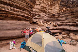 Camp LifeSeven days down, seven to go. We had reached the halfway point of our trip, and had already seen and done so much that it felt like we had been away for a month - but in a good way. But there was still lots of fun and excitement awaiting us over the next 7 days.
Today I would experience both my trip highlight and trip lowlight, all in the span of one hour. As Charles Dickens once said, “It was the best of times, it was the worst of times.” I’ll explain more later.
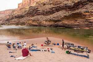 Breakfast cookingThe day started like any other on the river: rising to the 5:00 call for “COFFEE,” the guides cooking us breakfast in the kitchen down by the river, taking down our camp and loading everything onto the boats, and getting ready for another day on the river.
Then, we set off down the river for just only a mile or two before stopping at the entrance to Blacktail Canyon, which for me, as well as most of the others in our group, would be a true trip highlight.
.thumbnail.jpg) Let's hit the riverAfter beaching the rafts, we made our way up a short path and soon entered the cool, deeply shadowed world of Blacktail Canyon, a magnificent narrow slot canyon, less than a mile long, composed mostly of overhanging Tapeats Sandstone.
Let's hit the riverAfter beaching the rafts, we made our way up a short path and soon entered the cool, deeply shadowed world of Blacktail Canyon, a magnificent narrow slot canyon, less than a mile long, composed mostly of overhanging Tapeats Sandstone.
It felt like we were entering a cathedral. We found ourselves lowering our voices to a whisper. There was a sense of reverence and spirituality about the place.
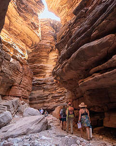 Entering Blacktail CanyonUnlike the smooth sandstone of other slot canyons we had been in, this one had angular blocky walls of stone, rising up steeply on both sides of a narrow, twisting and turning trail.
The walls were so close together that the sky was only visible through a very narrow gap at the top, revealing a fantasy land of stone and shifting shadows. The walls of the canyon were lit up in golden, turquoise and purple hues.
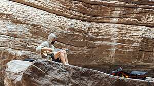 Ivan, our musical guidAlthough the canyon went on for almost a mile, dead-ending at a deep pool of dark green, algae-filled water, most of us stopped less than halfway through, because we found Ivan, one of our guides, sitting on a large rock with his guitar.
As Ivan started to play, we all sat down on the nearest rock, because no one wanted to leave. This was much more interesting than an algae-filled pool.
The acoustics in the canyon were beautiful and the music was mesmerizing.
.thumbnail.jpg) Cosmo joins inEventually Ivan shared his guitar with Cosmo, the most amazing 13-year-old I have ever met, who played a beautiful rendition of House of the Rising Sun.
Cosmo joins inEventually Ivan shared his guitar with Cosmo, the most amazing 13-year-old I have ever met, who played a beautiful rendition of House of the Rising Sun.
We leaned back, listening,and gazing up at the sky through the narrow canyon walls.
It was truly a magical moment which none of us would forget. Back on the river, the guides told us that even they had never had such a moving and spiritual experience in that canyon before. Thank you Ivan and Cosmo (plus others: Tim, Gib, Van, and Paolo).
.thumbnail.jpg) We were mesmerizedBesides its sense of reverence and great acoustics, there was one other thing about Blacktail Canyon that was special, but in a geological way.
We were mesmerizedBesides its sense of reverence and great acoustics, there was one other thing about Blacktail Canyon that was special, but in a geological way.
The Grand Canyon is a geologist’s paradise, because its distinct layers of rock, ranging from 200 million to almost 2 billion years old, allow geologists to study the earth’s history. The oldest rocks are on the bottom and the youngest rocks are on the top
.thumbnail.jpg) Looking upOccasionally, however, there are gaps in the geological record that occur when rocks or sediment are eroded away, and time goes by before new deposition occurs and forms new rock layers on top of the eroded surface. This missing piece of the geological record is called a “uniformity,” or sometimes “The Great Unconformity” (TGU).
Looking upOccasionally, however, there are gaps in the geological record that occur when rocks or sediment are eroded away, and time goes by before new deposition occurs and forms new rock layers on top of the eroded surface. This missing piece of the geological record is called a “uniformity,” or sometimes “The Great Unconformity” (TGU).
Well, it turns out that one of the best places to see and touch a TGU is in Blacktail Canyon, where 500 million year old Tapeats Sandstone (lighter colored rock) sits directly atop 1.75 billion year old Metamorphic Gneiss, leaving a 1.2 billion year gap in the geologic record. You can actually span all that missing time with your thumb and forefinger.
.thumbnail.jpg) Walls of Blacktail CanyonUnfortunately, I only found out about this after doing research when I got home.
Walls of Blacktail CanyonUnfortunately, I only found out about this after doing research when I got home.
Ok, that was the “good times.” Now onto the not so “good times.” After leaving the peace and tranquility of Blacktail Canyon, our day was about to drastically change.
Before we settled into camp tonight, we had two fairly big rapids to run, but nothing that required drawing them in the sand this morning or stopping to scout them out.
.thumbnail.jpg) Our little concert hallThe first one was Bedrock. This is a description of it from Western River Expeditions:
Our little concert hallThe first one was Bedrock. This is a description of it from Western River Expeditions:
An enormous chunk of hardened metamorphic and igneous rock splits the current in two. The best run is on the right side, which requires adept and precise handling to bring a craft around the rock and into calm water. The left side is an unforgiving place, as the river pinballs through a narrow rock studded channel.
Before entering the rapid, Kayla, whose boat we were in today, explained how she was going to take the line to the right side of the rock as suggested.
Unfortunately, that’s not what happened, resulting in what was the most terrifying moment of the trip - both for us in the boat, and our comrades behind watching.
.thumbnail.jpg) Back down the river we goRather than getting to the right of Bedrock (large boulder in the river) as we should, we were drawn too far to the left and slammed right into it, getting pinned and almost flipping the boat stern over bow. Herb and I were in the bow of the boat, which was tilted bow-side down at more than a 45 degree angle. Water was rushing in up to our knees.
Back down the river we goRather than getting to the right of Bedrock (large boulder in the river) as we should, we were drawn too far to the left and slammed right into it, getting pinned and almost flipping the boat stern over bow. Herb and I were in the bow of the boat, which was tilted bow-side down at more than a 45 degree angle. Water was rushing in up to our knees.
Kayla kept her cool and yelled for us to climb up to the back side of the boat that was sticking up in the air (the “high side”). I amazingly remained calm (for the moment anyway), and Herb and I were able to climb up over her seat and she grabbed my hand from the stern and pulled me into the stern.
.thumbnail.jpg) Aerial view of Bedrock RapidNow all five of us were crowded into the stern, which caused the weight to shift enough to set us free from the rock. Kayla jumped back into the rower’s seat and we went flying out of control to the left (wrong) side of the rock, hitting a few more rocks along the way before finally ending up in the pool at the end, where everyone greeted us with cheers.
Aerial view of Bedrock RapidNow all five of us were crowded into the stern, which caused the weight to shift enough to set us free from the rock. Kayla jumped back into the rower’s seat and we went flying out of control to the left (wrong) side of the rock, hitting a few more rocks along the way before finally ending up in the pool at the end, where everyone greeted us with cheers.
Kayla had to do all that with just one oar, because one of the oarlocks was twisted out of position.
She had done a great job getting us out of a very precarious situation which could have had a much worse result.
.thumbnail.jpg) Stone Creek WaterfallThe calm I had managed during the height of the crisis was now gone, and I was shaking and could hardly speak. Herb’s first words: “You can plan the next vacation.”
Stone Creek WaterfallThe calm I had managed during the height of the crisis was now gone, and I was shaking and could hardly speak. Herb’s first words: “You can plan the next vacation.”
The amazing thing was that Herb’s camera, which was strapped onto one of the bags in the bow, had held on. Even more amazing, when he went to pick it up afterwards, the strap broke in his hands. Somehow it had stayed on long enough to get through the chaotic and violent slamming in the rapid, but decided it didn’t need to anymore. Thank God or we would have lost all the photos we had taken so far.
For some reason, Herb didn’t have his GoPro running through this rapid, so I had to go on the internet to find an aerial view of Bedrock Rapid. Wow!
 Safelyl settled into campI was a bit shaken, but we had to get right back on the horse again, because Deubendorff Rapid (9), an even bigger rapid, was just around the bend.
At this point I was pretty numb. Kayla ran it perfectly and we were home free (at least for today).
Immediately after running Bedrock and Deubendorff rapids, we pulled onto a beach and walked the short distance to picturesque Stone Creek Waterfall. It was lovely and I finally had stopped shaking.
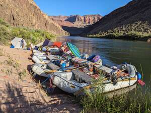
.thumbnail.jpg) River cocktail hourThat afternoon when we landed at Thunder River Camp (Mile 135), our guides announced that we would be staying there for two nights, rather than our usual one.
River cocktail hourThat afternoon when we landed at Thunder River Camp (Mile 135), our guides announced that we would be staying there for two nights, rather than our usual one.
WOO HOO! We practically danced with joy at the thought of not having to take down camp tomorrow morning and set up camp again somewhere down the river again tomorrow night.
.thumbnail.jpg) Thunder River HikeFinally, a day of leisure - hahaha. Who was I kidding. The guides had an 8-hour hike planned for tomorrow.
Thunder River HikeFinally, a day of leisure - hahaha. Who was I kidding. The guides had an 8-hour hike planned for tomorrow.
Well, we would worry about that tomorrow. Tonight all I wanted to do was join my friends in the river for cocktail hour. A warm beer never tasted better.
The next morning we awoke as always at 5:00 am to the sound of one of our river guides announcing “COFFEE.” But today was going to be different, because for the first time the entire trip we would be staying in the same campsite for two nights.
.thumbnail.jpg) Thunder River HikeSo no rushing around taking down the tent, packing our bags, forming a fireline, and loading up the boats.
Thunder River HikeSo no rushing around taking down the tent, packing our bags, forming a fireline, and loading up the boats.
This morning we had a more leisurely breakfast, but not too leisurely, because today we were hiking from the campsite to Thunder River Falls, a strenuous 8-mile (out-and-back) hike with 2,500 feet elevation gain, which would take us an estimated 8 hours.
.thumbnail.jpg) Crossing Tapeats CreekSome in our group were concerned about being able to go the whole distance, especially in 108 degree weather, which was a valid concern.
Crossing Tapeats CreekSome in our group were concerned about being able to go the whole distance, especially in 108 degree weather, which was a valid concern.
However, not everyone had to go the whole distance, because there would be several shaded areas along the way for people to just hang out and stay cool while the rest of us went on.
Plus, there would be places along Tapeats Creek to jump in and cool off.
.thumbnail.jpg) Cooling off in TapeatsSo off we went.
Cooling off in TapeatsSo off we went.
Although the hike was called the Thunder River hike, the first three miles of it were actually along Tapeats Creek, which cascades through a lovely open valley.
We had to cross Tapeats Creek twice on the way up to Thunder River. The current was really strong, so we all linked arms while carefully maneuvering ourselves over slippery rocks to the other side of the creek.
.thumbnail.jpg) Getting closeOne of our guides stood guard a little bit downstream to catch us if we slipped.
Getting closeOne of our guides stood guard a little bit downstream to catch us if we slipped.
We also took several breaks along the way to cool ourselves off in the creek. There was one particular section that was like a water slide that everyone found particularly fun and refreshing.
.thumbnail.jpg) Thunder River Falls3 miles into the hike, we came to the confluence where the Thunder River flowed into Tapeats Creek.
Thunder River Falls3 miles into the hike, we came to the confluence where the Thunder River flowed into Tapeats Creek.
At this point the trail made a sharp left, as we moved away from Tapeats Creek and started tracing the Thunder River.
The trail really began to climb more steeply now as we hiked the remaining mile to the Falls.
We knew we were getting close when we saw about a dozen small waterfalls cascading out of the limestone canyon walls. It looked like the walls had sprung a leak.
A little bit further and we arrived at the main event - Thunder Creek Falls, a stunning waterfall erupting from the side of a steep canyon wall.
.thumbnail.jpg) Thunder River FallsFrom there, it flows ½-mile downstream into Tapeats Creek, making it one of the shortest rivers in the world. During that ½-mile it drops approximately 1,200 feet over a series of waterfalls, also making it the steepest river in the country. It’s very rare for a river to be a tributary of a creek.
Thunder River FallsFrom there, it flows ½-mile downstream into Tapeats Creek, making it one of the shortest rivers in the world. During that ½-mile it drops approximately 1,200 feet over a series of waterfalls, also making it the steepest river in the country. It’s very rare for a river to be a tributary of a creek.
The mist it threw off was so refreshing.
We had already gone through 2 liters of water each on the way up, so we were very relieved that the guides had brought a water filter so we could refill our water bottles from the falls - the first ice cold water we had had in over a week. Water never tasted so good.
.thumbnail.jpg) The long way downAfter a while, we tore ourselves away and began the long, steep trek down, repeating the two stream crossings we did on the way up.
The long way downAfter a while, we tore ourselves away and began the long, steep trek down, repeating the two stream crossings we did on the way up.
Funny story on one of the stream crossings. I mentioned how we all linked arms and gingerly navigated our way across, stepping sideways along slippery rocks. I happened to be linking arms with Mitchell, one of the assistant guides, when I mentioned that I had found a particularly good foothold. He very nonchalantly replied, “That’s my foot.” We both started laughing hysterically.
We eventually caught up with the part of our group (about 5) that stayed behind on the shady ledges. They looked a lot less tired than we did, but I wouldn’t have missed this hike for the world.
- ‹ previous
- 9 of 14
- next ›
Day 8 and 9 - 119 Mile Rapid (119) to Thunder River Camp (Mile 134) location map in "high definition"
Javascript is required to view this map.
