- Home
- About
- Map
- Trips
- Bringing Boat West
- Migration West
- Solo Motorcycle Ride
- Final Family XC Trip
- Colorado Rockies
- Graduates' XC Trip
- Yosemite & Nevada
- Colorado & Utah
- Best of Utah
- Southern Loop
- Pacific Northwest
- Northern Loop
- Los Angeles to NYC
- East Coast Trips
- Martha's Vineyard
- 1 Week in Quebec
- Southeast Coast
- NH Backpacking
- Martha's Vineyard
- Canadian Maritimes
- Ocracoke Island
- Edisto Island
- First Landing '02
- Hunting Island '02
- Stowe in Winter
- Hunting Island '01
- Lake Placid
- Chesapeake
- Provincetown
- Hunting Island '00
- Acadia in Winter
- Boston Suburbs
- Niagara Falls
- First Landing '99
- Cape Hatteras
- West Coast Trips
- Burning Man
- Utah Off-Roading
- Maui
- Mojave 4WD Course
- Colorado River Rafting
- Bishop & Death Valley
- Kauai
- Yosemite Fall
- Utah Off-Road
- Lost Coast
- Yosemite Valley
- Arizona and New Mexico
- Pescadero & Capitola
- Bishop & Death Valley
- San Diego, Anza Borrego, Joshua Tree
- Carmel
- Death Valley in Fall
- Yosemite in the Fall
- Pacific Northwest
- Utah Off-Roading
- Southern CA Deserts
- Yosemite & Covid
- Lake Powell Covid
- Eastern Sierra & Covid
- Bishop & Death Valley
- Central & SE Oregon
- Mojave Road
- Eastern Sierra
- Trinity Alps
- Tuolumne Meadows
- Lake Powell Boating
- Eastern Sierra
- Yosemite Winter
- Hawaii
- 4WD Eastern Sierra
- 4WD Death Valley +
- Southern CA Deserts
- Christmas in Tahoe
- Yosemite & Pinnacles
- Totality
- Yosemite & Sierra
- Yosemite Christmas
- Yosemite, San Diego
- Yosemite & North CA
- Seattle to Sierra
- Southwest Deserts
- Yosemite & Sierra
- Pacific Northwest
- Yosemite & South CA
- Pacific Northwest
- Northern California
- Southern Alaska
- Vancouver Island
- International Trips
- Index
- Tips
- Books
- Photos/Videos
- Search
- Contact
Lassen Volcanic National Park, CA
Saturday, September 28, 2013 - 3:45pm by Lolo
171 miles and 4 hours from our last stop - 1 night stay
Travelogue
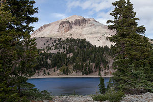 Lassen PeakEvery since friends of ours had visited Lassen and raved about the hike to its peak, I have been determined to get there. Plus, it's probably the last of the major parks in the West that we haven’t checked off our list.
Last year on our trip out west in early-June, we were thwarted by park road closures. There is really a very limited time that you can visit this park, as the roads are typically snow covered from mid-October through mid-June.
This time the roads were open, but the trail to Lassen Peak was closed for a multi-year trail maintenance project. Since climbing to the summit was our major reason for going there, we toyed at first as to whether we should bother, or just wait for another year. However, since it wasn’t too far off route, we decided to go anyway and check it out for a future visit. Plus, there were other interesting things to see in the park.
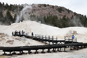 Bumpass Hell BoardwalkWe entered the park through the north entrance and booked a campsite at Manzanita Lake, not far from the Visitor Center. Although we thought we would stay 2 nights—really the minimum to really explore a park—something made us book only 1. We figured that since the park wasn’t crowded, we could easily add another day later if we chose to.
After stopping in the Visitor Center and confirming once again that we in fact could not hike up Lassen Peak, we drove the 30-mile scenic drive through the park towards Bumpass Hell, the park’s largest hydrothermal area.
We obviously were not the only ones that had the 1.3-mile hike to Bumpass Hell in mind, and the parking lot for the trailhead was quite full. For the first mile or so, the trail traversed the rocky slope of Bumpass Mountain. The trail was fairly level, but the 8,000 foot elevation could make things a little challenging if you are not acclimated to the altitude.
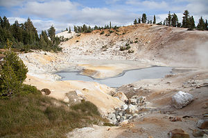 Bumpass Hell PoolAt about 1.2 miles we arrived at the basin overlook, where we gazed out over the bubbling hot springs, boiling mud pots, and hissing steam vents below. A short descent of 100 vertical feet brought us onto a series of boardwalks that allowed us to get safely up close to these amazing geothermal features. It very much reminded me of a mini Yellowstone.
It obviously is very important to not stray off these boardwalks. If they had only been there in 1865 when Kendal Bumpass discovered this place, he would still have his leg. Well, actually he is long dead, but he would have enjoyed a full life with two legs. He made the mistake of walking on a thin crust which broke, plunging his leg into a boiling pool. Hence, the need for boardwalks.
The source of these hot springs and vents is an underground reservoir of boiling water that lies beneath the park. Bumpass Hell is the principle discharge area for that steam. Like Yellowstone, Lassen is still a very active geothermal region.
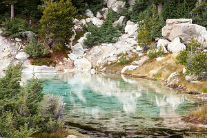 Geothermal PoolEverything was so colorful. The waters were bright blue and emerald green, and the soil around them were a bright yellow and orange, all stained by sulphur and other minerals in the area. This place was beautiful. Not my idea of Hell at all. The trip to Lassen was worth it just for this.
On the drive back to the campground, we stopped at the Lassen Peak trailhead parking lot, just to look. For a brief moment we considered hiking halfway up, which you are allowed to do, but figured we would come back and do it right when the trail eventually reopened.
Once back at the campground, we took a walk down to Manzanita Lake with our Crazy Creek chairs and a cooler. After sitting by the edge of the lake awhile, I got a bit antsy and asked Herb if he wanted to walk around the lake with me. He was pretty set with his beer and a view of the lake, so I went off alone. I wasn’t more than a ¼ of a mile away before Lassen Peak appeared in the distance. I had no idea that it would be visible from here. I ran back to Herb and told him that he just had to come and see this. We put the cooler and chairs in the car and set off on the trail together, clockwise around the lake.
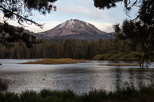 Lassen Peak over Manzanita LakeThe views just kept getting better and better, especially on the other side of the lake where you could see the mountain reflected in its waters. I am so, so glad that I took that exploratory walk, because this was just too good to have missed.
That night bad weather moved in bringing light rain, strong winds, and a steep drop in temperatures. It was supposed to be like that the whole next day. The next morning when we looked out the window at our poor fellow tent campers, we thanked Lazy Daze for providing us such a warm and cozy shelter. I was also glad that I didn’t book a second night here, because with this weather we would just be huddled in the motorhome all day, which actually isn’t bad sometimes. However, today we decided to move on south, gradually making our way back to San Francisco.
Description
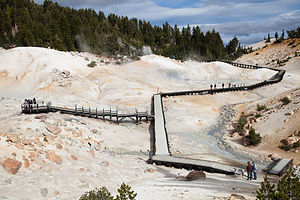 Overlook at Bumpass HellLassen Volcanic National Park in northern California contains Lassen Peak, the southernmost volcano in the Cascade Volcanic Arch, which extends for over 700 miles from British Columbia through Washington and Oregon to northern California. The Cascade Volcanoes are part of the Pacific Ring of Fire, the ring of volcanoes and associated mountains around the Pacific Ocean.
10,457 foot Lassen Peak is the largest plug dome volcano in the world. These types of plug or lava domes are formed when the ejected lava is too viscous to flow very far, and instead piles over and around its vent, creating a big dome over the volcano.
Although dormant now, Lassen Peak was the site of the most recent volcanic eruption in northern California. It began in 1914, spewing rock, gas, and hot ash billowing into the atmosphere. In 1915 it blew a cloud of ash almost 6 miles high and triggered a mudflow, known as a lahar, which wiped out a 5 square kilometer area now called the Devastated Area, which can still be seen today. It erupted for seven years before finally settling down in 1921.
The park is the only place in the world where all four types of volcano can be found: plug dome, shield, composite, and cinder cone. In addition, in Bumpass Hell in the southern part of the park there are bubbling hot springs, boiling mud pots, and fumaroles in six geothermal fields.
If you only have a day to visit the park, the best way to see it is to drive the 30-mile Lassen Volcanic National Park Highway, stopping at various highlights along the way. Starting from the northwest entrance, the following are some highlights along the way:
- Manzanita Lake – the iconic photo of the park is Lassen Peak reflected in this beautiful lake. It is also a good place to kayak, fish, or hike around its shores.
- Loomis Museum where one can view artifacts and photographs from the park’s 1914-1915 eruption
- Chaos Crags and Jumbles Scenic Pull-out – the site of an avalanche 350 years ago from the Chaos Crags lava domes, which scattered hundreds of thousands of large rocks over a couple of square miles
- Devastated Area – a ½-mile interpretative trail looks through the devastation caused by Lassen’s 1914 eruption
- Summit Lake – the midpoint between the northern and southern entrances, this is a great place to take a dip in Summit Lake or to stroll around it on the loop trail.
- Kings Creek picnic area – lovely spot to stop for lunch where the Kings Creeks flows through a meadow at the foot of Lassen Peak
- Lassen Peak Parking Area and Viewpoint – this is the highest point on the park road at 8,512 feet. From here you can just enjoy the view or, for the more adventurous, hike the strenuous 2 ½ mile to the summit, where you can look into the rim or out over the entire park. (This trail is currently closed for trail maintenance beyond the halfway point)
- Bumpass Hell – a 3 mile roundtrip hike brings you up close to bubbling hot springs, boiling mud pots, hissing steam vents (fumaroles)
- Sulphur Works Thermal Area – located near the southern entrance to the park, this is the most easily accessible hydrothermal area, where paved walks lead past boiling springs, burbling mudpots, and sulphur-emitting steam vents.
There are three campgrounds along the Lassen Volcanic National Park Highway that accommodate RVs:
- Manzanita Lake Campground – located near the northwest entrance to the park and adjacent to Manzanita Lake. The campground offers swimming, fishing, kayaking, and hiking. It is the largest of the Lassen campgrounds with 179 sites, some of which can be reserved. It is open from the end of May until it snows.
- Crags Campground – located five miles south of Manzanita Lake on the main park road. The campground offers easy access to the Lost Creek and Devastated Areas, in addition to Crags and Manzanita Lake. There are 45 RV sites, and operates on a first-come-first-served basis. It is open from mid-June to mid-September.
- Summit Lake Campgrounds - located 12 miles south of Manzanita Lake. The campground is comprised of a North and South section, each with access to the lake. There are 94 sites, some of which can be reserved. Summit Lake North is open from late June through mid-September and Summit Lake South is open from late June through late October.
- ‹ previous
- 14 of 19
- next ›
Lassen Volcanic National Park location map in "high definition"
Javascript is required to view this map.
