- Home
- About
- Map
- Trips
- Bringing Boat West
- Migration West
- Solo Motorcycle Ride
- Final Family XC Trip
- Colorado Rockies
- Graduates' XC Trip
- Yosemite & Nevada
- Colorado & Utah
- Best of Utah
- Southern Loop
- Pacific Northwest
- Northern Loop
- Los Angeles to NYC
- East Coast Trips
- Martha's Vineyard
- 1 Week in Quebec
- Southeast Coast
- NH Backpacking
- Martha's Vineyard
- Canadian Maritimes
- Ocracoke Island
- Edisto Island
- First Landing '02
- Hunting Island '02
- Stowe in Winter
- Hunting Island '01
- Lake Placid
- Chesapeake
- Provincetown
- Hunting Island '00
- Acadia in Winter
- Boston Suburbs
- Niagara Falls
- First Landing '99
- Cape Hatteras
- West Coast Trips
- Burning Man
- Utah Off-Roading
- Maui
- Mojave 4WD Course
- Colorado River Rafting
- Bishop & Death Valley
- Kauai
- Yosemite Fall
- Utah Off-Road
- Lost Coast
- Yosemite Valley
- Arizona and New Mexico
- Pescadero & Capitola
- Bishop & Death Valley
- San Diego, Anza Borrego, Joshua Tree
- Carmel
- Death Valley in Fall
- Yosemite in the Fall
- Pacific Northwest
- Utah Off-Roading
- Southern CA Deserts
- Yosemite & Covid
- Lake Powell Covid
- Eastern Sierra & Covid
- Bishop & Death Valley
- Central & SE Oregon
- Mojave Road
- Eastern Sierra
- Trinity Alps
- Tuolumne Meadows
- Lake Powell Boating
- Eastern Sierra
- Yosemite Winter
- Hawaii
- 4WD Eastern Sierra
- 4WD Death Valley +
- Southern CA Deserts
- Christmas in Tahoe
- Yosemite & Pinnacles
- Totality
- Yosemite & Sierra
- Yosemite Christmas
- Yosemite, San Diego
- Yosemite & North CA
- Seattle to Sierra
- Southwest Deserts
- Yosemite & Sierra
- Pacific Northwest
- Yosemite & South CA
- Pacific Northwest
- Northern California
- Southern Alaska
- Vancouver Island
- International Trips
- Index
- Tips
- Books
- Photos/Videos
- Search
- Contact
Death Valley National Park, CA
Tuesday, February 13, 2024 - 8:00am by Lolo
163 miles and 3 hours from our last stop - 4 night stay
Travelogue
Day 1 - Father Crowley Vista Point, Badwater Basin (Lake Manly), and Artist's Palette
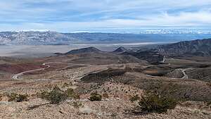 View from Father Crowley Vista PointOn the drive into Death Valley along Highway 190, near the western boundary of the Park, we stopped at the Father Crowley Vista Point where there are stunning views over Rainbow Canyon, a colorfully striped canyon created by ancient volcanic activity.
Most visitors stop at the first parking lot, but we continued to drive the additional ¼ mile on a dirt road to Padre Point, overlooking the Panamint Valley and the twisty roads we would soon be driving on.
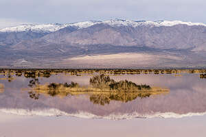 Ephemeral Pond near Panamint SpringsThere are many places in the Eastern Sierra named after the beloved Father Crowley, a catholic priest who in the 1930s was responsible for ministering to the people of the Inyo County Parish, traveling hundreds of miles to serve his parishioners.
He would often stop at this beautiful spot to admire the views on his way to or from visiting parishioners in Death Valley, and his home in Lone Pine, CA.
 Badwater Basin (Lake Manly)Continuing along Highway 190 on our way to Furnace Creek, we came across a beautiful ephemeral pond created by the “atmospheric rivers” that had been hitting California. It was beautiful.
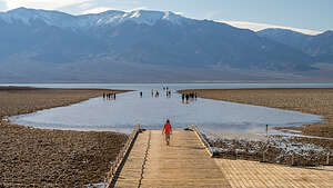
Now onto the main event and the major reason we just had to get over to Death Valley - seeing the once in a lifetime phenomenon of seeing Lake Manly covering the Badwater Basin.
As anyone who has visited Death Valley before, the Badwater Basin is normally a vast, surreal salt flat with beautiful crystalline patterns caused by salt crystals expanding and pushing through the surface. The salt formations stretch for nearly 200 square miles.
 Badwater Basin (Lake Manly)But now, because of the recent crazy weather pattern in the West of “atmospheric river” after “atmospheric river,” after 10,000 years, Lake Manly was back! reminding us that Death Valley was not always the dry place we think of today.
In fact, later we would discover even more ephemeral lakes and ponds popping up on the normally bone dry valley floor. It was now one big oasis!
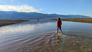
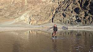 Badwater Basin (Lake Manly)Visitors to Badwater Basin have always strolled out onto the flats, and they weren’t going to let a little water stop them from doing that.
We just had to join them. While many chose to go barefoot, I charged in with my trail runners, which are now white rather than black from the residue of salt crystals in the water.
Herb smartly wore neoprene socks in anticipation of this activity.
.thumbnail.jpg) Artist's PaletteJust north of Badwater, there is a turnoff for Artist's Drive, a 9 ½ mile scenic drive where when the lighting is right, the rock turns multi-colored. Hence the name palette. It is one of the most photographed spots in Death Valley.
Artist's PaletteJust north of Badwater, there is a turnoff for Artist's Drive, a 9 ½ mile scenic drive where when the lighting is right, the rock turns multi-colored. Hence the name palette. It is one of the most photographed spots in Death Valley.
However, we were disappointed to see that this was one of the many roads marked as closed due to flooding on the NPS website.
Fortunately, as we were driving past the Artist's Drive turnoff, I glanced over and saw that the entry gates were open. We quickly turned in before any rangers could change their minds.
.thumbnail.jpg) Artist's Palette at sunsetAlthough there are many interesting geologic formations along Artist’s Drive, none of them are as dramatic as the vibrant multi-colored Artist’s Palette.
Artist's Palette at sunsetAlthough there are many interesting geologic formations along Artist’s Drive, none of them are as dramatic as the vibrant multi-colored Artist’s Palette.
Unlike the more subdued golds and browns of the Golden Canyon we hiked through yesterday, these hills are painted in turquoise, purple, red, pink, yellow, and green.
The vibrant colors of the Artist’s Palette are caused by the oxidation of different metals in the rock. Iron oxides produce reds, pinks, and yellows, while manganese minerals create lavender and purple hues. The decomposition of mica adds green tones to the palette.
It is absolutely stunning.
Day 2 - Zabriskie Point Sunrise and Ridge Hike, Furnace Creek Ranch Pool, and back to Artist's Palette
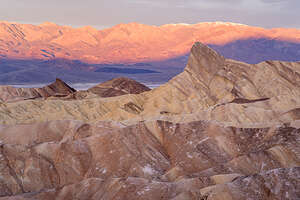 Sunrise at Zabriskie PointThe next morning we got up early to get to Zabriskie Point in time for sunrise. It is definitely the most spectacular viewpoint in the park with its stunning panoramic view of Golden Canyon and the surrounding vibrantly colored badlands.
However, we were not the only ones with this idea. While most people stay on the concrete viewing platform, we like to hike down below for more unobstructed views.
That pointy rock formation is 7,196-foot-high Manly Peak, named after William Lewis Manly, an early pioneer who scouted this area in 1849, while searching for a viable wagon train route out of Death Valley.
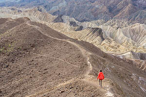 Setting out on the Zabriskie Ridge TrailThis Manly guy must have been pretty important, because the flooded Badwater Basin is also called Lake Manly.
To the left of Manly Peak, there are some beautiful yellow, tan, and brown badlands. As we looked down, we could see tiny people hiking through the badlands.
We planned to do that later this week along our favorite trail in the Valley, through Golden Canyon from the Valley floor up Gower Gulch and through the Badlands and along the base of the other side of Manly Peak.
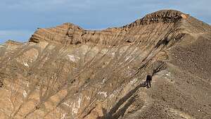 Zabriskie Ridge TrailAs we walked back towards the car, we noticed several people hiking up on the ridge just to the west of the parking lot. Gee, we had never thought of going up there before.
We discovered that we could walk along a somewhat precarious trail along the ridge to the right of the viewing platform.
It rose quite steeply at first requiring a little bit of scrambling over rocks. After a while the trail continued along a series of undulating with steep drop-offs on either side of the narrow trail.
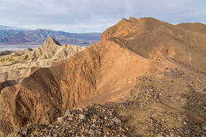 Tiny me on the Zabriskie Ridge TrailPlus, the trail was covered with loose rocks (scree) causing us to slip and slide a bit, especially on the downhills.
The views, however, were breathtaking, except you don’t want to walk and look at the same time or you risk taking a pretty bad tumble.
Golden Canyon and Manly Peak were constantly before us and presented a different perspective than that at the viewing platform.
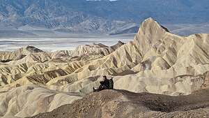 Herb taking a break on the Zabriskie Ridge TrailThe area below is where the Golden Canyon hike would take us in a few days, where we would actually get to hike along the base of the backside of Manly Peak.
This trail seemed to go on and on with no end in sight, but we decided to turn around after a little less than a mile, knowing that downhill would be harder than up because of the scree.
So glad we discovered this gem of a trail after so many years coming here, but better late than never.
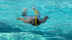 Furnace Creek Ranch poolAfter our ambitious sunrise event, we headed back to the Furnace Creek Ranch where we were staying for a well-needed nap. Normally, we like to camp out in the remoter parts of Death Valley in our 4Runner, but not this time of year, when it gets dark by 6:00 pm.
The Furnace Creek Ranch is quite nice - comfortable rooms, very nice grounds, a large pool, two restaurants, an ice cream parlor, a general store, and even a Borax mining museum.
Rather than rushing right out again after our nape, we thought it would be a nice change to have a little down time and relax poolside on a lounge chair for a few hours.
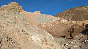 Wandering through Artists PaletteOf course, we don’t do well with downtime, so Herb and I both decided to swim a mile (54 laps) in the pool. We must have been inspiring, because by the time we were done there were three more people that had joined us.
Our plan for the late afternoon / evening was to return to Artist’s Palette, but this time hike down from the parking area into the badlands to wander amongst the colorful rocks.
Before leaving the Furnace Creek Ranch, I suggested we stop in at the two restaurants to see what we might want to do for dinner tonight. We were suprised to find how pricey they were with somewhat limited options. All I wanted was a hamburger and a salad.
.thumbnail.jpg) Wandering over Artists PaletteWhen I stopped in at the Last Kind Words Saloon, I was told that a reservation was required, but the first one available was for 8:00. Wow! So, I grabbed it. It was pretty pricey, with most of the steaks over $50, but they have a very captive audience here, so we were kind of stuck.
Wandering over Artists PaletteWhen I stopped in at the Last Kind Words Saloon, I was told that a reservation was required, but the first one available was for 8:00. Wow! So, I grabbed it. It was pretty pricey, with most of the steaks over $50, but they have a very captive audience here, so we were kind of stuck.
We then checked out the 1849 Buffet, but the pickings didn’t look very appetizing, especially for $34 per person, so I guess we would just stick with our reservation for the Saloon later.
On our drive to Artist’s Palette, we noticed that the exit for the one-way drive was blocked off by cones. Oh no! Did they close it again?
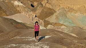 Wandering through Artists PaletteWe figured we would just continue on and go to Badwater Basin again. However, when we got to the entrance to Artist’s Drive, we saw that the gate was open, so we quickly drove in.
On our way to Artist’s Palette, we passed only two cars, and when we got to the parking lot, there was nobody there. This lot is usually packed, especially at this time of day.
Were we perhaps the only ones that got through the open gates?
We headed down into the canyon from the parking area and began wandering around and over the colorful hills. There really were no set trails, so we just went whichever way looked good.
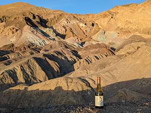 Good place for cocktail hourSometimes that meant climbing up steep hills to see what was on the other side, which did often reap rewards. However, that also meant slipping and sliding, and even getting on my butt, to get down them again.
The whole time we were there, we only saw 4 more people - very different from the usual crowds. We began to think that they might have closed the entry gate to the road again.
We probably wandered around for about a mile before returning up the hill to the parking lot, where the view out across the expanse of the badlands was really the best.
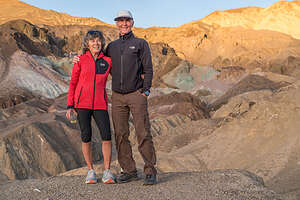 Artists PaletteThere was no other car in the parking lot and it was sunset. Were we locked in? We weren’t too worried because while the entry was blocked by a locked gate, the exit just had a few construction cones indicating closure which we could easily move.
We figured we might as well enjoy having the place to ourselves, so we grabbed a bottle of wine and climbed up the steep hill just to the right of the parking lot.
From there we watched as the golden hour literally turned some rocks gold and others and amazing turquoise and purple. It seemed unreal.
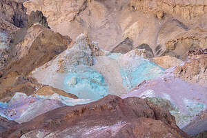 Sunset at Artists PaletteBy the time we left it was already getting dark. As we got to the Artist’s Drive exit, sure enough there were construction cones blocking our way. So we had managed to squeeze a visit in during the short time it was open. How lucky for us.
We had dinner that night at 8:00 at the Last Kind Word Saloon. Someone had warned us to stay away from the $50 - $80 steaks and just get the more reasonable Flat iron steak, which we did. It was pretty good, but didn’t arrive until well after 8:30 because they were short staffed in the kitchen.
Boy did we miss Andrew and Celeste’s hospitality and great cooking. Tomorrow night we would resort to our stash of backpacking mails which we always have packed in our truck.
Day 3 - Zabriskie Point Sunrise again, Random Salt Flats, Badwater Basin (Lake Manly), and Golden Canyon Hike
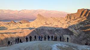 Sunrise gang at Zabriskie PointThe next morning we arose at 6:00 again to get to Zabriskie Point in time to watch the sun rise. This time there was a whole gang of photographers down below the viewing platform, where most people stay, where we normally like to position ourselves.
Plenty of room for all of us though. Besides, Herb wanted to focus (no pun intended) on the area of badlands down below to the left.
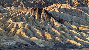 Badlands below Zabriskie PointWe decided to not go back out on the Ridge today, because we already had a big hike planned for the day, the Gower Gulch / Golden Canyon hike, where we would be down in those views rather than above looking down on them.
The light in Golden Canyon is best in the late afternoon, so we had plenty of time to kill before going over there to hike.
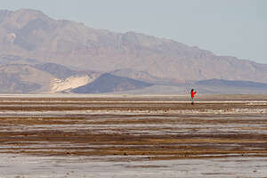 Random salt flatsWe decided to check out Lake Manly again, hoping that morning light would provide us with more reflections than the other day.
On the way there, we stopped on the side of the road at some interesting salt flats that were not underwater, although Lake Manly did extend this far north.
Knowing there would be plenty of mud to get through on the way across the flats to the lake, I decided to put on my snow boots, which I had packed for our time in Bishop.
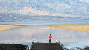 Lake ManlyGood thing I did, because it definitely did get quite muddy the closer we got to water.
It was extremely pretty and serene. No crowds here, and no kayakers out on the lake this far up.
When we got to the main Badwater Basin parking lot there was only one other car there. Morning was obviously the best time to be here.
Besides the lack of crowds, or maybe because of, the water was calm and flat as glass, making a perfect surface for reflections.
.thumbnail.jpg) Lake Manly reflectionsI quickly ran down to the end of the ramp - funny, it’s actually not a ramp, but now that Badwater is a lake, that seemed like an appropriate term. I wanted to have this view to myself.
Lake Manly reflectionsI quickly ran down to the end of the ramp - funny, it’s actually not a ramp, but now that Badwater is a lake, that seemed like an appropriate term. I wanted to have this view to myself.
Herb wasted no time, except for making him take a photo of me on the ramp, getting out in the water to take photos of the Panamint Range reflected in the “lake.”
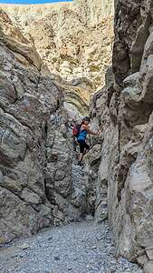 Lolo scrambling up Gower GulchThe purples of the early morning light were stunning.
What a full day it had already been, and it was only 9:30. We had earned the right to just sit by the pool all day, but that wasn't going to happen, as Golden Canyon in afternoon light was calling out to us.
We headed back to the Ranch for a quick lunch and a nap (we were up well before sunrise) before heading out for our main event of the day - the Golden Canyon hike, probably Death Valley’s most popular hike. We had done this hike numerous times before, but it was definitely worth a repeat.
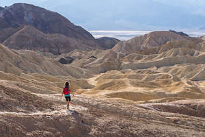 Along the Badlands LoopIt gets dark by 5:30 this time of year, so we headed out around 1:00, which would give us plenty of time to cover the 7+ miles we had planned, plus time to just enjoy and photograph the magnificent scenery.
Since the Golden Canyon is the most spectacular section of the hike, we decided to do it in reverse, so we would hit it in the golden hour right before sunset.
This meant starting off along the trail that ran parallel to Badwater Road for about three-quarters of a mile before turning left into Gowers Gulch.
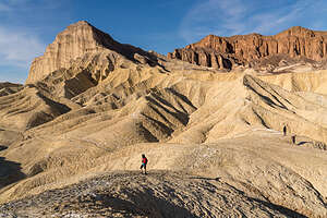 Approaching Manly PeakThere was a bit of scrambling and climbing up rocks in the beginning of the Gulch, but then we pretty much followed a wide, gravel-filled wash before coming to a choice at 2.3 miles.
We could go left on the Gower Gulch Cutoff, which would make the entire hike about 4.5 miles, or continue on to Zabriskie Point. We had done both in the past.
Even though we didn’t plan on going all the way to the viewing platform at Zabriskie Point, as we had been there several times already on this trip, including this morning, we went that direction anyway because we knew the views were better than along the Gulch Cutoff.
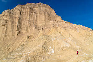 Intimidating Manly Peak3.1 miles into our hike, we came to another junction - right to the Zabriskie Point viewing platform or left onto the Badlands Loop, which would bring us across the badlands and eventually down to Golden Canyon.
"Badlands" seemed like such an inaccurate name for something so beautiful. I guess from a settler’s point of view, these were "bad" lands because of their inhospitable conditions: extreme temperatures, barrenness, lack of water, and exposed rugged terrain.
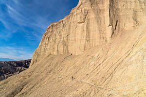 Traversing narrow trail at Manly Peak baseI prefer to think of them as “goodlands” because they are so restorative to the soul.
The section over to the top of the Golden Canyon Trail is probably the most dramatic, with its colorful rock formations - Red Cathedral, Manly Peak, and other ones that I didn’t know the names of.
There were several places where we got off the main trail to climb up a short spur trail to a better vantage point. Most of them were pretty short out-and-backs, but another one, which was a new one for us, was ½-mile out-and-back to a perspective of the badlands that we hadn’t seen before.
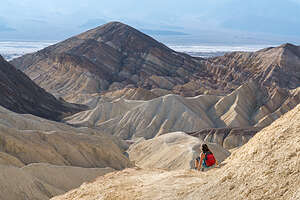 Not too dignified to crab crawl on buttWe were now getting into the area of badlands that we had looked down on from Zabriskie Point this morning, but now, rather than looking down on Manly Peak from afar, we were up quite close and personal to its backside, traversing its base on a rather precariously narrow trail. At 7,162 feet it's pretty impressive and intimidating.
It was hard to keep our eyes on the trail because the scenery was so beautiful, but we had to as there were parts of the way down that were a bit sketchy, with loose scree and steep drop-offs. I was not too proud to get down on my butt and crab walk when necessary.
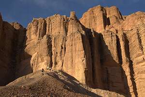 Red CathedralAs we approached the Golden Canyon, we debated whether we had time before it got dark to take the Red Cathedral spur. The trailhead sign said it was only ½ mile, so we figured we could knock off the 1-mile, out-and-back in a half hour.
The first four tenths of a mile we moved at a pretty good clip, and I thought the hike was over because we stood at the base of the tall red-rock columns, which we assumed to be the Red Cathedral.
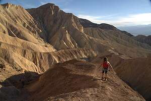 Promontory at end of Red Cathedral trailAt first I thought that the hike was over - after all, we were standing at the base of what was obviously the Red Cathedral. But then Herb discovered a small trail against the back wall.
Curious as to where it could possibly lead, we followed it, and spent the next tenth of a mile rock scrambling and clawing our way up a steep hill of loose rocks. I didn’t even want to think about how we would get down from here.
The last part involved us navigating our way to the end of a promontory along a narrow trail with steep drop-offs on either side. Assuming I make it safely back to the car, I would say that this spur trail definitely did not disappoint.
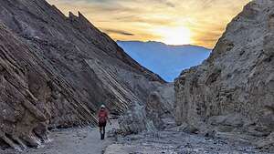 Barely making it out by sunsetIt took us a while to get back down to the base of the Red Cathedral, most of which was spent sliding on my butt, because it was so steep (probably more than 45 degrees) and covered in scree that I could not walk upright like the primate I was without risking breaking something.
Well, obviously we did make it back and just in time to see the sun dipping behind the mountains as we approached the end of Golden Canyon.
Wow! That was some hike - 7.7 miles with over 1,300 feet elevation gain and a very high Wows to miles ratio.
Now it was back to the Furnace Creek Ranch where Herb cooked me a delicious dinner of Mountain House Pad Thai.
Day 4 - More salt flats, Mosaic Canyon, and Mesquite Dunes
.thumbnail.jpg) Salt FlatsFor our last day in Death Valley we were switching hotels and moving to Stovepipe Wells for a change of scenery and easy access to the Mesquite Dunes.
Salt FlatsFor our last day in Death Valley we were switching hotels and moving to Stovepipe Wells for a change of scenery and easy access to the Mesquite Dunes.
On the drive up, we stopped at another salt flat, one that was not covered with water as the Badwater Basin was.
So why is Death Valley so salty? After some googling, I learned the following:
.thumbnail.jpg) Herb of the Salt FlatsDeath Valley was once covered by a 600-foot deep massive lake, called Lake Manly (which has temporarily come back to life in a smaller form).
Herb of the Salt FlatsDeath Valley was once covered by a 600-foot deep massive lake, called Lake Manly (which has temporarily come back to life in a smaller form).
As the water evaporated after the last Ice Age (10,000 to 15,000 years ago), salts and other minerals that had been deposited in the lake were concentrated and left as a thick layer of salt on the valley floor.
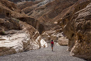 Heading into Mosaic CanyonThese salts continue to get replenished today as floods rush down the surrounding mountains bringing dissolved minerals along the way and depositing them in the enclosed Badwater Basin. Since this basin has no outlet to the sea, the salts remain there and form a dense salt layer on the ground.
While not dramatic like the Golden Canyon, these salt flats are beautiful in their own way, with interesting patterns created by the salt.
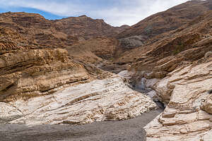 Mosaic CanyonSince it was too early to check in to our Stovepipe Wells Room, we continued past the hotel to the nearby trailhead for Mosaic Canyon, considered by many to be Death Valley’s best hike, or at least a close second to Golden Canyon.
Mosaic is more of a slot canyon compared to Golden with much narrower passageways and rocks to scramble over.
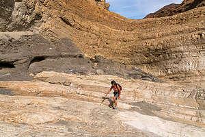 Mosaic CanyonThe trailhead is at the end of Mosaic Canyon Road, a 2-mile dirt road (navigable by most passenger cars) just across the street from the Stovepipe Wells Village Hotel.
After parking, we headed into the mouth of Lower Mosaic Canyon, a narrow slot that weaves its way between wavy white walls of water-polished white marble and blue-gray conglomerate rocks.
The reason the marble is so polished in this canyon, as opposed to other canyons in Death Valley, is that the ground is much more gravely. During flash floods, the fast moving water mixes with the gravel, scouring the sides of the canyon walls, or “polishing” it. As a result, this rock is very slippery, so we had to be careful when scrambling over it.
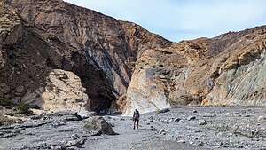 Mosaic CanyonThe conglomerate rocks get water polished as well, giving them the appearance of mosaic tiles grouted into the canyon wall, hence the name Mosaic Canyon.
The best examples of polished marble occur in the first quarter mile into the hike, so you could turn around here and still consider it a wonderful hike.
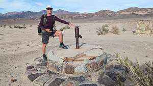 The real Stovepipe WellsAt about a half mile, the canyon opened up to an expansive gravel wash, marking the top of the lower canyon, and the place where many people turn around, making it a very rewarding, short 1-mile hike.
We decided to do the same, because we had a longer hike planned for this afternoon at Mesquite Dunes.
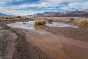 Ephemeral Pond by Mesequite DunesWe stopped back at the Stovepipe Wells Village Hotel where our room was not ready to make lunch before heading out again to hike the Mesquite Dunes, but from around the backside rather than from the parking lot just across the road.
The lighting on the dunes is dependent on the season. In the winter time, which we were now closest to, sunrise is best on the front side of the dunes (by the main parking lot), but sunset is best on the back side, reached via a longer walk from the Historic Stovepipe Well.
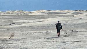 Dune Ho!So, since better lighting, and less crowds, is important to us, we headed out to the Old Stovepipe Wells site, where there is an historical marker and the actual “Stovepipe Well” which Stovepipe Wells is named for.
It was now obvious to us where the name “Stovepipe” came from, as there was an actual pipe extending up from the well. The story goes that early prospectors used a length of stovepipe to mark the location of the spring because it often got obscured by blowing sand.
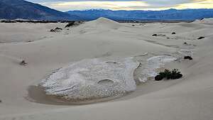 Mysterious circlesThis particular waterhole stood at the junction of two Indian trails. During the bonanza days of Rhyolite and Skidoo it was the only known water source on the cross-valley road.
From here we started walking out towards the dunes, which were much smaller than the ones seen from the main parking lot.
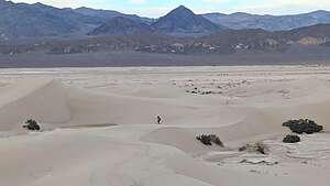 Mesquite DunesThe Mesquite sand dunes stretch over 7 miles, so we knew we were not going to get to the main dune area and the tallest “Star Dune.”
In fact, it was close to a one mile walk just to get to the beginning of them. Walking was easy however, as much of the surface was hard
packed dirt rather than deep sand.
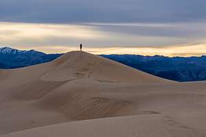 Lolo of the dunesHowever, unlike the last time we were here, we did have to cross the occasional pond or mud that had sprung up from the recent “atmospheric rivers” of rain.
The presence of water had also created some very interesting patterns in the sand that Herb became fascinated with photographing.
Eventually we came to the dunes, and began climbing up them, so much easier than the taller ones at Eureka or even at the main Mesquite Dunes section.
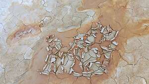 Patterns in the sandThese smaller dunes were beautiful in their own way - less dramatic, but more intimate and peaceful. There wasn’t another soul to be seen for miles. I think very few people explore this section of the dunes.
We were determined to find an interesting feature that we had stumbled upon last time, a rocky section at the base of several small dunes with two crater-like circles, about 8 feet in diameter. We had been so intrigued by them that Herb had actually sent a photo to the National Park Service a few years back to see if they could get an explanation as to what created them. They were unable to do so. It looked to us very much like small meteorites.
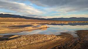 Ephemeral Lake near Mesquite DunesI think we had a better answer this time - water pooling on the surface. Or, it still could be aliens.
After almost two hours of hiking, we decided it was time to head back if we wanted to make it before it got dark. Hmm…which way did we come?
We really weren’t worried about finding out way back because we were using both Strava and Gaia to record our hike. Both of these apps provide tracks which allow you to follow the breadcrumbs back home.
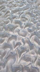 Patterns in the sandWhen we were almost back, I noticed what looked like a pretty good-sized body of water off to our right. I called to Herb, but he was too busy photographing patterns in the sand to come with me to check it out.
It was pretty amazing. Hard to believe we were in Death Valley.
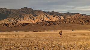 Back before sunsetGreat hike. We felt like we were the only people in the world, or at least our small part of it.
Back at Stovepipe Wells Village Hotel, we walked over to the Badwater Saloon, hoping for a better experience than the Last Kind Words Saloon in Furnace Creek. It was. At least they had hamburger options, which were very good.
Another great day. What an awesome trip it had been!
- ‹ previous
- 2 of 2
